IMAGES TAKEN NEAR TO
Hill Street, WREXHAM, LL11 6DA
Introduction
This page details the photographs taken nearby to Hill Street, LL11 6DA by members of the Geograph project.
The Geograph project started in 2005 with the aim of publishing, organising and preserving representative images for every square kilometre of Great Britain, Ireland and the Isle of Man.

There are currently over 7.5m images from over14,400 individuals and you can help contribute to the project by visiting https://www.geograph.org.uk
Image Map
Images are licensed for reuse under creativecommons.org/licenses/by-sa/2.0
Notes
- Clicking on the map will re-center to the selected point.
- The higher the marker number, the further away the image location is from the centre of the postcode.
Image Listing (7 Images Found)
Images are licensed for reuse under creativecommons.org/licenses/by-sa/2.0
Image
Details
Distance
1
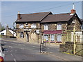
The Castle Inn, Brynteg
Local in a area of traditional house clustering on steep hills.
http://www.enjoyengland.com/campaign/taste/tasteengland/Tours/Marstons.aspx
Image: © John Haynes
Taken: 29 Apr 2006
0.14 miles

3
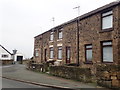
Cottages on the High Street, Pentre Broughton
Image: © Eirian Evans
Taken: 16 Nov 2018
0.21 miles
4
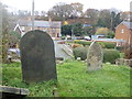
Old gravestones at Caersalem burial ground
The chapel, Caersalem, was demolished in 1981 but the local History group take care of the graveyard.
Image: © Eirian Evans
Taken: 16 Nov 2018
0.21 miles
5
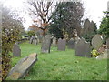
Gravestones at St Paul's Churchyard, Pentre Broughton
Image: © Eirian Evans
Taken: 16 Nov 2018
0.23 miles
6
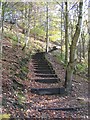
Flight of steps at Moss Valley Country Park
This flight of steps links the lower path along the bottom of Moss Valley with the high level path through the woods. See also the same steps from the top Image http://www.wrexham.gov.uk/english/leisure_tourism/moss_valley.htm
The steps are not marked on the O.S.maps but are shown on Magic Map.
Image: © John S Turner
Taken: 7 Nov 2008
0.24 miles
7
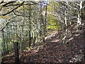
Steps down at the Moss Valley Country Park
This flight of steps links the high level footpath, in the northern part of the Moss Valley Country Park, with the footpath along the bottom of the valley. http://www.wrexham.gov.uk/english/leisure_tourism/moss_valley.htm
Image: © John S Turner
Taken: 7 Nov 2008
0.24 miles