IMAGES TAKEN NEAR TO
Colliery Road, WREXHAM, LL11 5NY
Introduction
This page details the photographs taken nearby to Colliery Road, LL11 5NY by members of the Geograph project.
The Geograph project started in 2005 with the aim of publishing, organising and preserving representative images for every square kilometre of Great Britain, Ireland and the Isle of Man.

There are currently over 7.5m images from over14,400 individuals and you can help contribute to the project by visiting https://www.geograph.org.uk
Image Map
Images are licensed for reuse under creativecommons.org/licenses/by-sa/2.0
Notes
- Clicking on the map will re-center to the selected point.
- The higher the marker number, the further away the image location is from the centre of the postcode.
Image Listing (12 Images Found)
Images are licensed for reuse under creativecommons.org/licenses/by-sa/2.0
Image
Details
Distance
1
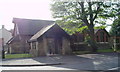
All Saints, Southsea
The church was formerly the church hall, but the original church had to be demolished. About 40 miles from the nearest sea, the village was named in the rate books of 1786, deriving its name from the Southsea Inn in Broughton. ..... Here the wages of the miners and colliers at most of the works in the neighbourhood were paid once a fortnight. http://www.clwydfhs.org.uk/churches/Southsea/
Image: © Eirian Evans
Taken: 11 Aug 2006
0.05 miles
3
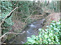
Afon Gwenfro
Between Southsea and Tanyfron
Image: © Eirian Evans
Taken: 19 Jan 2008
0.09 miles
4
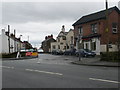
Southsea near Wrexham
Southsea is a small formerly industrial village on the Gwenfro river. It came into being at the site of the Broughton Hall Brickworks and the Plas Power Colliery. Its exotic English name comes from the South Sea Inn which used to stand over the road from the Brickworks (and in a room of which the Brickworks pay was distributed).
Image: © Eirian Evans
Taken: 19 Jan 2008
0.09 miles
5
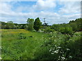
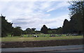
A couple of hectares of wild countryside
How good it is that near to houses is a genuine piece of "wild" countryside.
Image: © John Haynes
Taken: 1 Jun 2016
0.12 miles
6
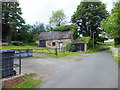
Local but now closed blacksmith and farrier
Could not find out much about it. The nearby house is a family home.
Image: © John Haynes
Taken: 1 Jun 2016
0.17 miles
7
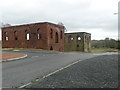
Old industrial buildings, Plas Power
These buildings are now within an industrial estate where there was once a colliery.
Image: © Eirian Evans
Taken: 19 Jan 2008
0.17 miles
8
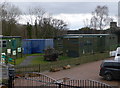
Plas Power Environmental Education Centre
Run by the Woodland Trust, for the benefit of local schoolchildren who come mainly from urban areas.
Image: © Eirian Evans
Taken: 19 Jan 2008
0.17 miles
9
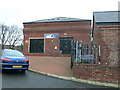
Plas Power Adventure
On the site of the Plas Power colliery, this sports centre has indoor climbing walls and runs climbing courses for all ages.
Image: © Eirian Evans
Taken: 19 Jan 2008
0.17 miles
10
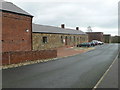
Plas Power
The site of the old colliery at Plas Power has been turned into a small industrial estate. It is between Southsea and Tanyfron, to the west of Wrexham.
Image: © Eirian Evans
Taken: 19 Jan 2008
0.17 miles