IMAGES TAKEN NEAR TO
Pleasant Lane, WREXHAM, LL11 5DH
Introduction
This page details the photographs taken nearby to Pleasant Lane, LL11 5DH by members of the Geograph project.
The Geograph project started in 2005 with the aim of publishing, organising and preserving representative images for every square kilometre of Great Britain, Ireland and the Isle of Man.

There are currently over 7.5m images from over14,400 individuals and you can help contribute to the project by visiting https://www.geograph.org.uk
Image Map
Images are licensed for reuse under creativecommons.org/licenses/by-sa/2.0
Notes
- Clicking on the map will re-center to the selected point.
- The higher the marker number, the further away the image location is from the centre of the postcode.
Image Listing (21 Images Found)
Images are licensed for reuse under creativecommons.org/licenses/by-sa/2.0
Image
Details
Distance
1
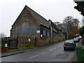
Brymbo Church of England School
This school on the High Street in Brymbo has long since closed.
Image: © Eirian Evans
Taken: 27 Nov 2007
0.05 miles
2
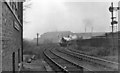
Site of Brymbo West Crossing Halt
View SE, toward Brymbo and Wrexham; ex-Great Western, Wrexham - Brymbo - Minera (Berwig Halt) line. The Halt closed when the passenger service ceased on 1/1/31, but the line remained open for goods until 1/10/82. A Down freight is approaching, headed by a 56XX 0-6-2T; beyond is Brymbo Steelworks.
Image: © Ben Brooksbank
Taken: 19 Apr 1962
0.10 miles
3
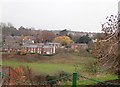
Brymbo houses
From Green Lane, Pentre Broughton
Image: © Eirian Evans
Taken: 16 Nov 2018
0.11 miles
4
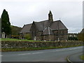
St Mary's Church, Brymbo
A church was built for Brymbo in 1838, but unfortunately it began to collapse because of subsidence due, most probably, to extensive coal-mining in the area. This church was built in 1871, a short distance from the site of the first church.
Image: © Eirian Evans
Taken: 27 Nov 2007
0.12 miles
5
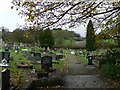
Cemetery at St Mary's Church, Brymbo
To the north of the town of Brymbo and on a very sharp corner of the B5101.
Image: © Eirian Evans
Taken: 27 Nov 2007
0.12 miles
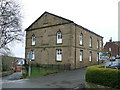
6
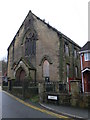
Engedi, Brymbo
Built in 1820, this was a Welsh Presbyterian chapel. It was enlarged in 1840, rebuilt in 1861 and again in 1895.
Image: © Eirian Evans
Taken: 27 Nov 2007
0.12 miles
7
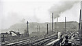
Brymbo: southward at Brymbo Middle Signalbox, 1962
View towards Brymbo (GWR) station and Wrexham to left, towards Vron Colliery to right. Brymbo Steelworks dominates the background. This a typical scene of heavy industry 50+ years ago. See also Image], Image] and Image
Image: © Ben Brooksbank
Taken: 19 Apr 1962
0.14 miles
8
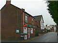
Brymbo Post Office, High Street, Brymbo
Image: © Eirian Evans
Taken: 27 Nov 2007
0.14 miles
9
Tabernacle, Brymbo
Welsh Baptist chapel on the High Street in Brymbo, which was built in 1864. It has now been converted into flats.
Image: © Eirian Evans
Taken: 27 Nov 2007
0.14 miles
10
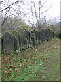
Brymbo memorial park
The graves from the old Baptist chapel in Brymbo have been lined up against the boundary of the memorial park, but not too near that you cannot read the inscriptions.
Image: © Eirian Evans
Taken: 27 Nov 2007
0.14 miles