IMAGES TAKEN NEAR TO
Dyke Street, WREXHAM, LL11 5AH
Introduction
This page details the photographs taken nearby to Dyke Street, LL11 5AH by members of the Geograph project.
The Geograph project started in 2005 with the aim of publishing, organising and preserving representative images for every square kilometre of Great Britain, Ireland and the Isle of Man.

There are currently over 7.5m images from over14,400 individuals and you can help contribute to the project by visiting https://www.geograph.org.uk
Image Map
Images are licensed for reuse under creativecommons.org/licenses/by-sa/2.0
Notes
- Clicking on the map will re-center to the selected point.
- The higher the marker number, the further away the image location is from the centre of the postcode.
Image Listing (21 Images Found)
Images are licensed for reuse under creativecommons.org/licenses/by-sa/2.0
Image
Details
Distance
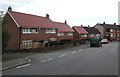
1
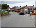
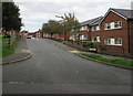
Dyke Street, Brymbo
Row of houses on the east side of Dyke Street.
Image: © Jaggery
Taken: 24 Sep 2016
0.05 miles
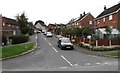
2
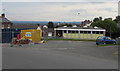
Former Brymbo Library
Viewed across Dyke Street in September 2016. The Daily Post reported in January 2014 that Wrexham council's executive board had voted to shut Brymbo and Gresford libraries and reduce the hours of the remaining 10 libraries in the county by 19% to save cash in the face of £13.8 million cuts for 2014/2015.
Image: © Jaggery
Taken: 24 Sep 2016
0.09 miles
3
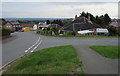
Junction of Edwards Avenue and Dyke Street, Brymbo
Edwards Avenue from the right joins Dyke Street.
Image: © Jaggery
Taken: 24 Sep 2016
0.09 miles
4
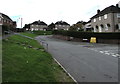
Dyke Street Brymbo
Viewed from the corner of Edwards Avenue looking along Dyke Street past the Cheshire View junction.
Image: © Jaggery
Taken: 24 Sep 2016
0.10 miles
5
Offa's Dyke at Mount Sion, Brymbo, 1961
On a school trip visiting several sections of the dyke in Flintshire.
Image: © Alan Murray-Rust
Taken: Unknown
0.10 miles
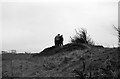
6
Offa's Dyke at Mount Sion, Brymbo, 1961
On a school trip visiting several sections of the dyke in Denbighshire. To the left of the dyke there is now a late 20th century housing development. The cottages just to the left of the walkers allowed me to establish the location of this view. Surprisingly this relatively well preserved section of the dyke has no modern views on Geograph, although aerial views do indicate that it is now much more overgrown than then.
Image: © Alan Murray-Rust
Taken: Unknown
0.11 miles
7
Up Davies Avenue, Brymbo
Davies Avenue ascends from Edwards Avenue.
Image: © Jaggery
Taken: 24 Sep 2016
0.16 miles
8
House and flats, Edwards Avenue, Brymbo
Flats in Morse House http://www.geograph.org.uk/photo/5132882 are on the right.
Image: © Jaggery
Taken: 24 Sep 2016
0.16 miles
9
Southwest end of Edwards Avenue, Brymbo
Looking to the northeast from the road named Mount Zion.
Image: © Jaggery
Taken: 24 Sep 2016
0.19 miles
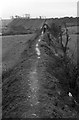
10
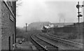
Site of Brymbo West Crossing Halt
View SE, toward Brymbo and Wrexham; ex-Great Western, Wrexham - Brymbo - Minera (Berwig Halt) line. The Halt closed when the passenger service ceased on 1/1/31, but the line remained open for goods until 1/10/82. A Down freight is approaching, headed by a 56XX 0-6-2T; beyond is Brymbo Steelworks.
Image: © Ben Brooksbank
Taken: 19 Apr 1962
0.19 miles