IMAGES TAKEN NEAR TO
Cherry Tree Road, WREXHAM, LL11 4DN
Introduction
This page details the photographs taken nearby to Cherry Tree Road, LL11 4DN by members of the Geograph project.
The Geograph project started in 2005 with the aim of publishing, organising and preserving representative images for every square kilometre of Great Britain, Ireland and the Isle of Man.

There are currently over 7.5m images from over14,400 individuals and you can help contribute to the project by visiting https://www.geograph.org.uk
Image Map
Images are licensed for reuse under creativecommons.org/licenses/by-sa/2.0
Notes
- Clicking on the map will re-center to the selected point.
- The higher the marker number, the further away the image location is from the centre of the postcode.
Image Listing (14 Images Found)
Images are licensed for reuse under creativecommons.org/licenses/by-sa/2.0
Image
Details
Distance
1
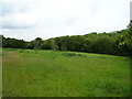
Grazing and woodland near the River Alyn, Bradley
Off the B5425.
Image: © JThomas
Taken: 25 May 2019
0.13 miles
2
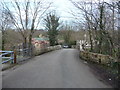
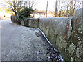
Bradley Mill Bridge and a bench mark
Looking across Bradley Mill Bridge on a frosty winter's morning. On the right of the photo there is an Ordnance Survey bench mark cut into the parapet of the bridge Image, and there are also a number of mason's marks cut into the stonework - Image The bridge crosses the River Alyn, and just beyond, on the right, is the entrance to Alyn Waters Country Park.
Image: © John S Turner
Taken: 29 Dec 2014
0.15 miles
3
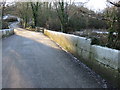
Old stone bridge over the Afon Alun / River Alyn near Bradley Mill Farm
An old bridge on a back lane.
Image: © Jeremy Bolwell
Taken: 9 Mar 2012
0.15 miles
4
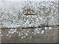
Mason's mark on Bradley Mill Bridge
This mark is cut into many of the stones in the bridge parapet, and this one is towards the north east end of the bridge. I assume that it is the mark of the mason who either built or restored the bridge. For a view of this mason's mark on the parapet in relation to the road see Image Opposite this mark on the west parapet is an Ordnance Survey bench mark Image
Image: © John S Turner
Taken: 29 Dec 2014
0.16 miles
5
Mason's mark on Bradley Mill Bridge #2
Looking along the extended parapet of Bradley Mill Bridge towards Bradley Mill. The River Alyn here is shallow and wide and the bridge has long parapets. On the right of the photo is a mason's mark Image, the design of which is repeated on many of the stone panels.
Image: © John S Turner
Taken: 29 Dec 2014
0.16 miles
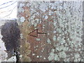
6
Bench mark on Bradley Mill Bridge
This bench mark is on the western parapet of the old stone bridge over the River Alyn Image, and was recorded on the 1872 O.S. map. The stonework of the bridge is interesting in that many of the panels have what seem to be the same mason's mark - Image
Image: © John S Turner
Taken: 29 Dec 2014
0.16 miles
7
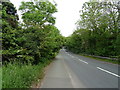
New Llay Road, Bradley
Looking north east on the B5425.
Image: © JThomas
Taken: 25 May 2019
0.16 miles
8
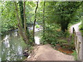
Afon Alun
The River Alyn in Alyn Waters Country Park / Parc Gwledig Dyfroedd Alun, close to Bradley Mill Bridge.
Image: © Derek Harper
Taken: 16 Jul 2006
0.17 miles
9
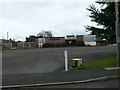
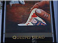
The Queens Head, Bradley
The Queens Head is the only Public House in Bradley and has changed hands a number of times. It closed the end of 2009.
Image: © Eirian Evans
Taken: 17 Feb 2012
0.17 miles