IMAGES TAKEN NEAR TO
Mold Road, WREXHAM, LL11 4AG
Introduction
This page details the photographs taken nearby to Mold Road, LL11 4AG by members of the Geograph project.
The Geograph project started in 2005 with the aim of publishing, organising and preserving representative images for every square kilometre of Great Britain, Ireland and the Isle of Man.

There are currently over 7.5m images from over14,400 individuals and you can help contribute to the project by visiting https://www.geograph.org.uk
Image Map
Images are licensed for reuse under creativecommons.org/licenses/by-sa/2.0
Notes
- Clicking on the map will re-center to the selected point.
- The higher the marker number, the further away the image location is from the centre of the postcode.
Image Listing (6 Images Found)
Images are licensed for reuse under creativecommons.org/licenses/by-sa/2.0
Image
Details
Distance
1
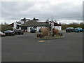
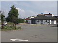
Visitor Centre at Alyn Waters Country Park
Alyn Waters is the largest country park in the Wrexham area and has waymarked woodland, grassland and riverside trails within the beautiful Alyn Valley. The park lies either side of the River Alyn. The park is on the site of a former gravel quarry and stretches to 400 acres.
Image: © Eirian Evans
Taken: 17 Feb 2012
0.01 miles
2
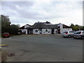
Visitors Centre at Alyn Waters Country Park
During the 16th century the Park was part of a large country estate with Gwersyllt Hall as the focal point. The hall was eventually demolished in 1910 due to mining subsidence and in 1953 MacAlpines bought the land to open quarries on the Gwersyllt and Llay sides of the Park. Wrexham Maelor Borough Council bought much of the land in 1988 and designated the area as a country park in 1989.
Image: © Richard Hoare
Taken: 30 Oct 2013
0.01 miles
3
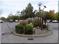
Sculpture at Alyn Waters Country Park
During the 16th century the Park was part of a large country estate with Gwersyllt Hall as the focal point. The hall was eventually demolished in 1910 due to mining subsidence and in 1953 MacAlpines bought the land to open quarries on the Gwersyllt and Llay sides of the Park. Wrexham Maelor Borough Council bought much of the land in 1988 and designated the area as a country park in 1989.
Image: © Richard Hoare
Taken: 30 Oct 2013
0.02 miles
4
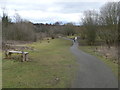
Start of a walk around Alyn Waters Country Park
Alyn Waters is the largest country park in the Wrexham area and has waymarked woodland, grassland and riverside trails within the beautiful Alyn Valley. The park lies either side of the River Alyn. The park is on the site of a former gravel quarry and stretches to 400 acres.
Image: © Eirian Evans
Taken: 17 Feb 2012
0.05 miles
5
Visitors centre at Alyn Waters Country Park, Wrecsam
This country park between the Mold Road (A541) and the Afon Alun, and incorporates several areas of reclaimed industrial sites.
Image: © John Haynes
Taken: 5 Sep 2005
0.05 miles
6
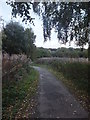
A leafy walk in Alyn Waters Country Park
On a dull autumnal day.
During the 16th century the Park was part of a large country estate with Gwersyllt Hall as the focal point. The hall was eventually demolished in 1910 due to mining subsidence and in 1953 MacAlpines bought the land to open quarries on the Gwersyllt and Llay sides of the Park. Wrexham Maelor Borough Council bought much of the land in 1988 and designated the area as a country park in 1989.
Image: © Richard Hoare
Taken: 30 Oct 2013
0.15 miles