IMAGES TAKEN NEAR TO
Llandegla, WREXHAM, LL11 3BG
Introduction
This page details the photographs taken nearby to LL11 3BG by members of the Geograph project.
The Geograph project started in 2005 with the aim of publishing, organising and preserving representative images for every square kilometre of Great Britain, Ireland and the Isle of Man.

There are currently over 7.5m images from over14,400 individuals and you can help contribute to the project by visiting https://www.geograph.org.uk
Image Map
Images are licensed for reuse under creativecommons.org/licenses/by-sa/2.0
Notes
- Clicking on the map will re-center to the selected point.
- The higher the marker number, the further away the image location is from the centre of the postcode.
Image Listing (9 Images Found)
Images are licensed for reuse under creativecommons.org/licenses/by-sa/2.0
Image
Details
Distance
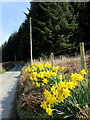
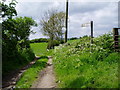
2
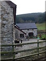
Trefydd Bychain
Smallholding on the Clwydian Way, near Llandegla
Image: © Eirian Evans
Taken: 25 Feb 2009
0.08 miles
3
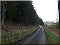
Clwydian Way
Heading towards Graig Farm
Image: © Eirian Evans
Taken: 25 Feb 2009
0.11 miles
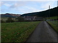
4
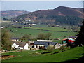
View towards Trefydd Bychain
View northwards from Offa's Dyke Path near Nant yr Hafod showing the farm below the feet of Llandegla Forest,
Image: © Chris Heaton
Taken: 10 May 2009
0.20 miles
7
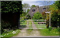
Offa's Dyke Path
The Offa's Dyke footpath, near Llandegla, seeming to go through someone's garden.
Image: © Eirian Evans
Taken: 25 May 2006
0.23 miles
8
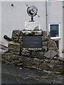
Plaque at the workshops, Hafod Bilston
Image: © Eirian Evans
Taken: 25 Feb 2009
0.23 miles
9
One mile to Llandegla
The footpath from Hafod Bilston to Llandegla
Image: © Eirian Evans
Taken: 25 May 2006
0.24 miles