IMAGES TAKEN NEAR TO
Llandegla, WREXHAM, LL11 3AB
Introduction
This page details the photographs taken nearby to LL11 3AB by members of the Geograph project.
The Geograph project started in 2005 with the aim of publishing, organising and preserving representative images for every square kilometre of Great Britain, Ireland and the Isle of Man.

There are currently over 7.5m images from over14,400 individuals and you can help contribute to the project by visiting https://www.geograph.org.uk
Image Map
Images are licensed for reuse under creativecommons.org/licenses/by-sa/2.0
Notes
- Clicking on the map will re-center to the selected point.
- The higher the marker number, the further away the image location is from the centre of the postcode.
Image Listing (13 Images Found)
Images are licensed for reuse under creativecommons.org/licenses/by-sa/2.0
Image
Details
Distance
2
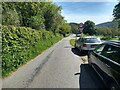
Car parking on the minor road at Pen-y-stryt
Image: © David Medcalf
Taken: 14 May 2019
0.12 miles
4
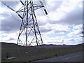
Pylons near Llandegla
Pylons marching down the Alyn valley, this one by the A525.
Image: © Eirian Evans
Taken: 14 Apr 2006
0.13 miles
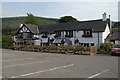
5
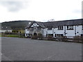
The Plough Inn, Llandegla
Beside the A525 Ruthin to Wrexham road.
Image: © Eirian Evans
Taken: 30 Mar 2016
0.15 miles
6
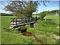
Footbridge across a tributary of the Afon Alun
Image: © David Medcalf
Taken: 14 May 2019
0.21 miles
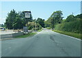
7
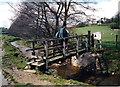
Croesi Pompren / Crossing Footbridge
Cerddwr yn croesi pompren wrth ddilyn Clawdd Offa tuag at Landegla.
Walker crossing a footbridge while following the Offa's Dyke Path towards the village of Llandegla (trans. St Tegla's Church).
Image: © Alan Richards
Taken: 22 Apr 2000
0.22 miles
8
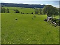
The Offa's Dyke path crosses fields near Pen-y-stryt
Image: © David Medcalf
Taken: 14 May 2019
0.22 miles
9
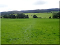
Offa's Dyke Path
South-east of Llandegla, heading for Llandegla Forest
Image: © Eirian Evans
Taken: 29 Aug 2020
0.22 miles
10
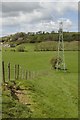
Fence and electricity pylon near Pen-y-stryt
Image: © Mark Anderson
Taken: 4 May 2019
0.23 miles