IMAGES TAKEN NEAR TO
Lorne Street, WREXHAM, LL11 2LR
Introduction
This page details the photographs taken nearby to Lorne Street, LL11 2LR by members of the Geograph project.
The Geograph project started in 2005 with the aim of publishing, organising and preserving representative images for every square kilometre of Great Britain, Ireland and the Isle of Man.

There are currently over 7.5m images from over14,400 individuals and you can help contribute to the project by visiting https://www.geograph.org.uk
Image Map
Images are licensed for reuse under creativecommons.org/licenses/by-sa/2.0
Notes
- Clicking on the map will re-center to the selected point.
- The higher the marker number, the further away the image location is from the centre of the postcode.
Image Listing (57 Images Found)
Images are licensed for reuse under creativecommons.org/licenses/by-sa/2.0
Image
Details
Distance
1
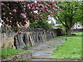
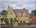
Dissenters' Burial Ground, Rhosddu Road, Wrexham
Now the Morgan Llwyd Memorial Park. Surviving headstones are arranged along the boundary walls.
Image: © A Jones
Taken: 9 May 2018
0.04 miles
2
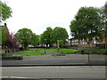
Dissenters' Burial Ground, Rhosddu Road, Wrexham
From a plaque: "Parc Goffa Morgan Llwyd/Morgan Llwyd Memorial Park.
"This ground, originally part of the common fields of Wrexham Regis, was for over two centuries used as a burial ground by Wrexham Dissenters. It was acquired about 1655 by the congregation gathered and ministered to by Morgan Llwyd o Wynedd (1619-59), author of 'Llyfr y Tri Aderyn' and other Welsh classics, who himself lies buried here. After his death the ground was maintained by The Old Meeting (now Chester Street Baptist Church), successors to Morgan Llwyd's congregation, by whose consent members of other dissenting bodies also used it for burial. It was officially closed in 1888, but a few later burials were permitted, the last being in 1901. In 1960 the ground was acquired by the Corporation and laid out as a park for the use of the borough and in commemoration of one of its distinguished sons.
"Opened 1st May 1963."
The monument to Morgan Llwyd was unveiled in 1912 by Mrs David Lloyd George.
Image: © A Jones
Taken: 9 May 2018
0.04 miles
3
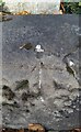
Ordnance Survey Rivet
This OS rivet can be found on the wallof No7 Grove Road. It marks a point 85.335m above mean sea level.
Image: © Adrian Dust
Taken: 22 Oct 2021
0.06 miles
4
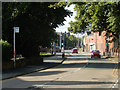
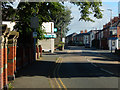
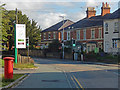
Rhosddu Road, Wrexham
Looking towards Wrexham town centre along the B5425.
Image: © Stephen McKay
Taken: 30 Jun 2019
0.06 miles
5
Rhosddu Road, Wrexham
Looking towards the junction with Garden Road; Rowlands Pharmacy is on the corner (closed in this Sunday morning view). To the left behind the wall is a recreation ground.
Image: © Stephen McKay
Taken: 30 Jun 2019
0.07 miles
6
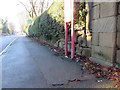
Grove Road and a bench mark
Looking south west along Grove Road past the bus stop. There is an Ordnance Survey bench mark on the stone on the right Image
Image: © John S Turner
Taken: 5 Jan 2015
0.08 miles
7
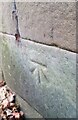
Bench mark in Grove Road, Wrexham
This bench mark is on a stone pillar at the boundary of #13 Grove Road. It is close to a bus stop. See also Image
Image: © John S Turner
Taken: 5 Jan 2015
0.08 miles
8
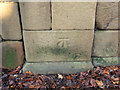
Ordnance Survey Cut Mark
This OS cut mark can be found on the wall of No13 Grove Road. It marks a point 85.167m above mean sea level.
Image: © Adrian Dust
Taken: 22 Oct 2021
0.09 miles
10
Rhosddu Road, Wrexham
To the left is a 24-hour Spar store which incorporates Rhosddu post office.
Image: © Stephen McKay
Taken: 30 Jun 2019
0.12 miles