IMAGES TAKEN NEAR TO
King Street, WREXHAM, LL11 1HE
Introduction
This page details the photographs taken nearby to King Street, LL11 1HE by members of the Geograph project.
The Geograph project started in 2005 with the aim of publishing, organising and preserving representative images for every square kilometre of Great Britain, Ireland and the Isle of Man.

There are currently over 7.5m images from over14,400 individuals and you can help contribute to the project by visiting https://www.geograph.org.uk
Image Map
Images are licensed for reuse under creativecommons.org/licenses/by-sa/2.0
Notes
- Clicking on the map will re-center to the selected point.
- The higher the marker number, the further away the image location is from the centre of the postcode.
Image Listing (321 Images Found)
Images are licensed for reuse under creativecommons.org/licenses/by-sa/2.0
Image
Details
Distance
1
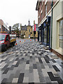
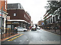
Stylish paving in King Street, Wrexham
This stylish paving is in King Street, and it replaces the previous plain and uninspiring tarmac.
Image: © John S Turner
Taken: 8 Nov 2013
0.02 miles
2
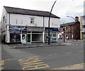
Vacant shop, Lord Street, Wrexham
Viewed in September 2016. The nameboard has been removed from the empty shop. Mobilapz electronic repair centre is on the left. Haywoods estate & letting agents and King Street are on the right.
Image: © Jaggery
Taken: 24 Sep 2016
0.03 miles
3
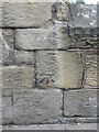
Bench mark on Wrexham Museum wall, St Marks Road
This Ordnance Survey bench mark is on the roadside wall of what is now Wrexham Museum and Art Gallery. Previously the Magistrates Court and Police Station, and prior to that it was built in 1857-8 as a militia barracks. See also Image
Image: © John S Turner
Taken: 10 Sep 2013
0.03 miles
4
The side wall and front courtyard of Wrexham Museum
Wrexham Museum and Art Gallery was previously the Magistrates Court and Police Station, and prior to that it was built in 1857-8 as a militia barracks. There is an Ordnance Survey bench mark on the roadside wall Image
Image: © John S Turner
Taken: 10 Sep 2013
0.03 miles
5
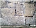
Ordnance Survey Cut Mark
This OS cut mark can be found on the Old Courts/Police Station building. It marks a point 86.786m above mean sea level.
Image: © Adrian Dust
Taken: 22 Oct 2021
0.03 miles
6
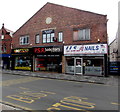
P.S.R. Solicitors, Lord Street, Wrexham
Office at 8 Lord Street between UK Vapes and USA Nails.
Image: © Jaggery
Taken: 24 Sep 2016
0.03 miles
7
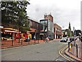
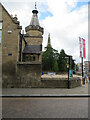
Wrexham Methodist Church
Yes, that modern building in the centre forms the entrance!
Image: © Roger Cornfoot
Taken: 22 Aug 2017
0.03 miles
8
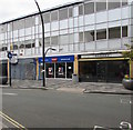
Swinton in Wrexham
Swinton Insurance office at 19 King Street Wrexham viewed in September 2016.
Image: © Jaggery
Taken: 24 Sep 2016
0.03 miles
10
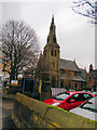
St Mary's catholic cathedral, Wrexham
Website: http://www.wrexhamcathedral.org.uk/
Image: © Paul Gillett
Taken: 16 Nov 2019
0.04 miles