IMAGES TAKEN NEAR TO
Arnolds Crescent, LEICESTER, LE9 9LA
Introduction
This page details the photographs taken nearby to Arnolds Crescent, LE9 9LA by members of the Geograph project.
The Geograph project started in 2005 with the aim of publishing, organising and preserving representative images for every square kilometre of Great Britain, Ireland and the Isle of Man.

There are currently over 7.5m images from over14,400 individuals and you can help contribute to the project by visiting https://www.geograph.org.uk
Image Map
Images are licensed for reuse under creativecommons.org/licenses/by-sa/2.0
Notes
- Clicking on the map will re-center to the selected point.
- The higher the marker number, the further away the image location is from the centre of the postcode.
Image Listing (31 Images Found)
Images are licensed for reuse under creativecommons.org/licenses/by-sa/2.0
Image
Details
Distance
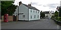
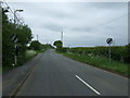
2
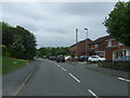
Brascote Lane, Newbold Verdon
Heading south.
Image: © JThomas
Taken: 23 May 2015
0.05 miles
3
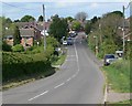
Newbold Verdon in Leicestershire
Heading north along Brascote Lane.
Image: © Mat Fascione
Taken: 3 May 2009
0.05 miles
4
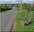
Bench along Brascote Lane
Looking towards the village of Newbold Verdon.
Image: © Mat Fascione
Taken: 3 May 2009
0.09 miles
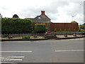
5
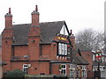
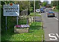
corner of Main St and Hornbeam Rd, Newbold Verdon
The Jubilee, in Newbold Verdon
Image: © Tammy Winand
Taken: 4 Feb 2006
0.09 miles
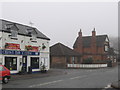
6
Entering Newbold Verdon along Brascote Lane
Image: © Mat Fascione
Taken: 3 May 2009
0.11 miles
7
Leaving Newbold Verdon
Heading south on Brascote Lane.
Image: © JThomas
Taken: 23 May 2015
0.11 miles