IMAGES TAKEN NEAR TO
Leicester Lane, LEICESTER, LE9 9JJ
Introduction
This page details the photographs taken nearby to Leicester Lane, LE9 9JJ by members of the Geograph project.
The Geograph project started in 2005 with the aim of publishing, organising and preserving representative images for every square kilometre of Great Britain, Ireland and the Isle of Man.

There are currently over 7.5m images from over14,400 individuals and you can help contribute to the project by visiting https://www.geograph.org.uk
Image Map
Images are licensed for reuse under creativecommons.org/licenses/by-sa/2.0
Notes
- Clicking on the map will re-center to the selected point.
- The higher the marker number, the further away the image location is from the centre of the postcode.
Image Listing (7 Images Found)
Images are licensed for reuse under creativecommons.org/licenses/by-sa/2.0
Image
Details
Distance
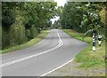
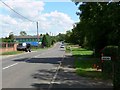
1
Leicester Lane, near Desford
The B582 looking towards Leicester. The green building on the left belongs to a plant nursery.
Image: © Kate Jewell
Taken: 21 Sep 2006
0.05 miles
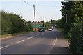
2
The B582 Leicester Lane
This building is marked on maps as a Stud Farm.
Image: © Mat Fascione
Taken: 7 Jul 2007
0.09 miles
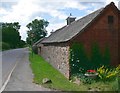
4
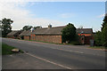
Stud Farm on Leicester Lane
Solid stone barns against the road built in the "crazy paving" style typical of this area of Leicestershire. The farmhouse behind is built of brick. Ubiquitous wheelie-bin by the gate!
Image: © Kate Jewell
Taken: 21 Sep 2006
0.14 miles
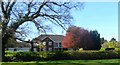
5
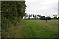
Public bridleway off Leicester Lane
This bridle way goes down the side of The Croft for about 100 yards and then turns into a footpath.
Image: © Kate Jewell
Taken: 21 Sep 2006
0.16 miles
6
Leicester Lane between Desford and Enderby
Image: © Mat Fascione
Taken: 7 Jul 2007
0.17 miles