IMAGES TAKEN NEAR TO
Lancaster Close, LEICESTER, LE9 9HW
Introduction
This page details the photographs taken nearby to Lancaster Close, LE9 9HW by members of the Geograph project.
The Geograph project started in 2005 with the aim of publishing, organising and preserving representative images for every square kilometre of Great Britain, Ireland and the Isle of Man.

There are currently over 7.5m images from over14,400 individuals and you can help contribute to the project by visiting https://www.geograph.org.uk
Image Map
Images are licensed for reuse under creativecommons.org/licenses/by-sa/2.0
Notes
- Clicking on the map will re-center to the selected point.
- The higher the marker number, the further away the image location is from the centre of the postcode.
Image Listing (14 Images Found)
Images are licensed for reuse under creativecommons.org/licenses/by-sa/2.0
Image
Details
Distance
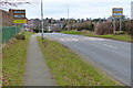
1
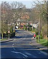
Peckleton Lane in Desford, Leicestershire
Image: © Mat Fascione
Taken: 17 Feb 2008
0.09 miles
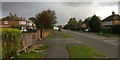
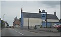
2
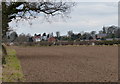
Farmland to the south of Desford
On the right is St. Martin's Church in Desford.
Image: © Mat Fascione
Taken: 3 Mar 2013
0.11 miles
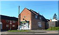
3
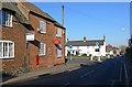
Desford Post Office
On the High Street.
Image: © Mat Fascione
Taken: 17 Feb 2008
0.16 miles
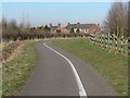
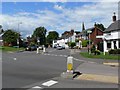
10
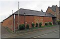
Building with flush bracket G2389
The flush bracket is to the right of the street sign post near the corner of the building on High Street Desford and clearly visible.
See Image
Image: © Andrew Tatlow
Taken: 12 Apr 2022
0.23 miles