IMAGES TAKEN NEAR TO
Howard Close, LEICESTER, LE9 8HY
Introduction
This page details the photographs taken nearby to Howard Close, LE9 8HY by members of the Geograph project.
The Geograph project started in 2005 with the aim of publishing, organising and preserving representative images for every square kilometre of Great Britain, Ireland and the Isle of Man.

There are currently over 7.5m images from over14,400 individuals and you can help contribute to the project by visiting https://www.geograph.org.uk
Image Map
Images are licensed for reuse under creativecommons.org/licenses/by-sa/2.0
Notes
- Clicking on the map will re-center to the selected point.
- The higher the marker number, the further away the image location is from the centre of the postcode.
Image Listing (3 Images Found)
Images are licensed for reuse under creativecommons.org/licenses/by-sa/2.0
Image
Details
Distance
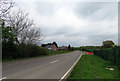
1
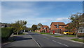
Stapleton Lane, Barwell
Stapleton Lane leaving Barwell near to its junction with Cumberland Way.
Image: © Peter Mackenzie
Taken: 23 Oct 2018
0.02 miles
3
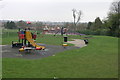
Busy Playground
Busy not with people but equipment and colour. Behind the hedge to the right is a cemetery.
Image: © Michael Patterson
Taken: 24 Apr 2006
0.22 miles