IMAGES TAKEN NEAR TO
Leicester Road, LEICESTER, LE9 8BB
Introduction
This page details the photographs taken nearby to Leicester Road, LE9 8BB by members of the Geograph project.
The Geograph project started in 2005 with the aim of publishing, organising and preserving representative images for every square kilometre of Great Britain, Ireland and the Isle of Man.

There are currently over 7.5m images from over14,400 individuals and you can help contribute to the project by visiting https://www.geograph.org.uk
Image Map
Images are licensed for reuse under creativecommons.org/licenses/by-sa/2.0
Notes
- Clicking on the map will re-center to the selected point.
- The higher the marker number, the further away the image location is from the centre of the postcode.
Image Listing (7 Images Found)
Images are licensed for reuse under creativecommons.org/licenses/by-sa/2.0
Image
Details
Distance
2
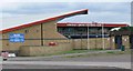
Marston's Stadium
The home of Hinckley United Football Club, located in the 22 acre De Montfort Park Complex. The Stadium opened in March 2005.
Image: © Mat Fascione
Taken: 28 Aug 2008
0.12 miles