IMAGES TAKEN NEAR TO
Moore Road, LEICESTER, LE9 8AG
Introduction
This page details the photographs taken nearby to Moore Road, LE9 8AG by members of the Geograph project.
The Geograph project started in 2005 with the aim of publishing, organising and preserving representative images for every square kilometre of Great Britain, Ireland and the Isle of Man.

There are currently over 7.5m images from over14,400 individuals and you can help contribute to the project by visiting https://www.geograph.org.uk
Image Map
Images are licensed for reuse under creativecommons.org/licenses/by-sa/2.0
Notes
- Clicking on the map will re-center to the selected point.
- The higher the marker number, the further away the image location is from the centre of the postcode.
Image Listing (7 Images Found)
Images are licensed for reuse under creativecommons.org/licenses/by-sa/2.0
Image
Details
Distance
2
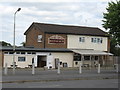
Barwell Boot & Shoe Pub
Pub away from the village centre on Moore Road.
Image: © the bitterman
Taken: 10 Jul 2010
0.12 miles
3

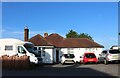
Belle Vue Road, Barwell
By Newlands School
Image: © David Howard
Taken: 17 Aug 2023
0.13 miles
5
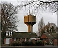
Barwell Water Tower and transmitter masts
Image: © Mat Fascione
Taken: 3 Jan 2017
0.22 miles
6
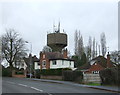
Houses and water tower, Barwell
View from Shilton Road.
Image: © JThomas
Taken: 25 Feb 2017
0.22 miles
7
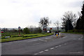
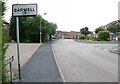
Earl Shilton
Looking South from the western approach to the village. The Village Sign can be seen centre left. An identical sign sits at the eastern end of the village.
Image: © Alan Simkins
Taken: 10 Apr 2005
0.22 miles