IMAGES TAKEN NEAR TO
Croft Road, LEICESTER, LE9 7TB
Introduction
This page details the photographs taken nearby to Croft Road, LE9 7TB by members of the Geograph project.
The Geograph project started in 2005 with the aim of publishing, organising and preserving representative images for every square kilometre of Great Britain, Ireland and the Isle of Man.

There are currently over 7.5m images from over14,400 individuals and you can help contribute to the project by visiting https://www.geograph.org.uk
Image Map
Images are licensed for reuse under creativecommons.org/licenses/by-sa/2.0
Notes
- Clicking on the map will re-center to the selected point.
- The higher the marker number, the further away the image location is from the centre of the postcode.
Image Listing (9 Images Found)
Images are licensed for reuse under creativecommons.org/licenses/by-sa/2.0
Image
Details
Distance
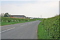
2
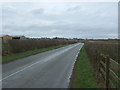
Croft Road
Looking north - direction Thurlaston.
Image: © JThomas
Taken: 25 Feb 2017
0.17 miles
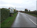
3
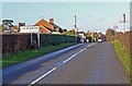
Croft Road enters Thurlaston
This is the southern edge of this Leicestershire village.
Image: © Mat Fascione
Taken: 4 Feb 2008
0.18 miles
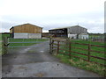
4
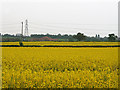
Farmland near Thurlaston, Leicestershire
Fields of oil seed rape between Croft Road and the M69 which is out of sight in a cutting just before the pylon.
Image: © Kate Jewell
Taken: 12 May 2006
0.19 miles
6
Entering Thurlaston
Looking north east on Croft Road.
Image: © JThomas
Taken: 25 Feb 2017
0.21 miles
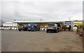
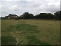
8
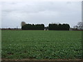
Crop field, Yennards Farm
Looking east from Croft Road.
Image: © JThomas
Taken: 25 Feb 2017
0.22 miles