IMAGES TAKEN NEAR TO
The Crescent, LEICESTER, LE9 7SQ
Introduction
This page details the photographs taken nearby to The Crescent, LE9 7SQ by members of the Geograph project.
The Geograph project started in 2005 with the aim of publishing, organising and preserving representative images for every square kilometre of Great Britain, Ireland and the Isle of Man.

There are currently over 7.5m images from over14,400 individuals and you can help contribute to the project by visiting https://www.geograph.org.uk
Image Map
Images are licensed for reuse under creativecommons.org/licenses/by-sa/2.0
Notes
- Clicking on the map will re-center to the selected point.
- The higher the marker number, the further away the image location is from the centre of the postcode.
Image Listing (12 Images Found)
Images are licensed for reuse under creativecommons.org/licenses/by-sa/2.0
Image
Details
Distance
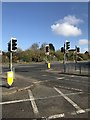
4
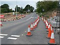
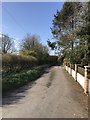
Building the Earl Shilton Bypass
Looking along Elmesthorpe Lane. This will probably become a busy junction or roundabout along the bypass.
Image: © Mat Fascione
Taken: 28 Aug 2008
0.16 miles
5
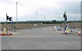
Building the Earl Shilton Bypass
This is where the future bypass will cross Elmesthorpe Lane.
Image: © Mat Fascione
Taken: 28 Aug 2008
0.16 miles
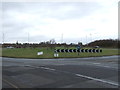
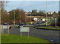
9
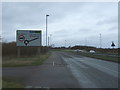
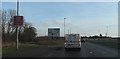
A47 approaching roundabout
Heading north east.
Image: © JThomas
Taken: 25 Feb 2017
0.20 miles