IMAGES TAKEN NEAR TO
Whitmore Grove, LE9 7RU
Introduction
This page details the photographs taken nearby to Whitmore Grove, LE9 7RU by members of the Geograph project.
The Geograph project started in 2005 with the aim of publishing, organising and preserving representative images for every square kilometre of Great Britain, Ireland and the Isle of Man.

There are currently over 7.5m images from over14,400 individuals and you can help contribute to the project by visiting https://www.geograph.org.uk
Image Map
Images are licensed for reuse under creativecommons.org/licenses/by-sa/2.0
Notes
- Clicking on the map will re-center to the selected point.
- The higher the marker number, the further away the image location is from the centre of the postcode.
Image Listing (12 Images Found)
Images are licensed for reuse under creativecommons.org/licenses/by-sa/2.0
Image
Details
Distance
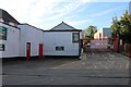
1

Mountfield Road
Mountfield Rd an unadopted road off the north side of Wood Street
Image: © Chris Wilson
Taken: 16 Oct 2006
0.12 miles
2
The entrance to Buildbase on Wood Street, Earl Shilton
Image: © David Howard
Taken: 17 Aug 2023
0.19 miles
3
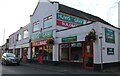
Buildbase on Wood Street, Earl Shilton
Image: © David Howard
Taken: 17 Aug 2023
0.20 miles
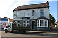
4
Earl Shilton Lord Nelson
54 Wood Street.
Image: © the bitterman
Taken: 5 Aug 2010
0.21 miles
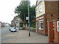
5
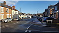
At Milton Street
Milton Street emerges onto Hinckley Road in Earl Shilton.
Image: © Peter Mackenzie
Taken: 28 Dec 2017
0.21 miles
6
Wood Street
Looking east along Wood Street from close to the Lord Nelson
Image: © Chris Wilson
Taken: 16 Oct 2006
0.21 miles
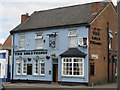
8
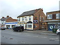
The Lord Nelson public house, Earl Shilton
On Wood Street.
Image: © JThomas
Taken: 25 Feb 2017
0.21 miles
9

The Lord Nelson
Looking east along Wood Street to 'The Hollow' past the Lord Nelson pub
Image: © Chris Wilson
Taken: 16 Oct 2006
0.23 miles
10
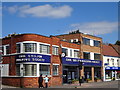
Earl Shilton Building Society
On Wood Street.
Image: © Ian Rob
Taken: 11 Apr 2019
0.23 miles