IMAGES TAKEN NEAR TO
Main Street, LEICESTER, LE9 7RE
Introduction
This page details the photographs taken nearby to Main Street, LE9 7RE by members of the Geograph project.
The Geograph project started in 2005 with the aim of publishing, organising and preserving representative images for every square kilometre of Great Britain, Ireland and the Isle of Man.

There are currently over 7.5m images from over14,400 individuals and you can help contribute to the project by visiting https://www.geograph.org.uk
Image Map
Images are licensed for reuse under creativecommons.org/licenses/by-sa/2.0
Notes
- Clicking on the map will re-center to the selected point.
- The higher the marker number, the further away the image location is from the centre of the postcode.
Image Listing (45 Images Found)
Images are licensed for reuse under creativecommons.org/licenses/by-sa/2.0
Image
Details
Distance
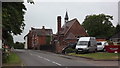
1
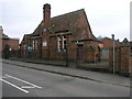
Village Hall
Peckleton's village hall looks like it may have been a school at one time.
Image: © Michael Patterson
Taken: 24 Apr 2006
0.03 miles
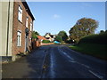
2
Main Street in Peckleton, Leicestershire
Image: © Mat Fascione
Taken: 17 Feb 2008
0.03 miles
3
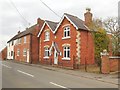
Peckleton Main Street
Houses next to the Village Hall.
Image: © Ian Rob
Taken: 5 Apr 2019
0.07 miles
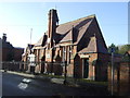
5
Peckleton Village Hall
Presumably, when built in 1877 it was the village school
Image: © John Welford
Taken: 2 Jul 2015
0.11 miles
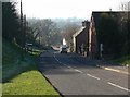
6
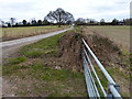
Gate along Church Road
Looking north towards the village of Peckleton.
Image: © Mat Fascione
Taken: 3 Mar 2013
0.11 miles
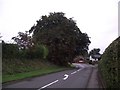
10
Peckleton Common heading towards Peckleton
Image: © Mat Fascione
Taken: 3 Mar 2013
0.14 miles