IMAGES TAKEN NEAR TO
Wilemans Close, LEICESTER, LE9 7GW
Introduction
This page details the photographs taken nearby to Wilemans Close, LE9 7GW by members of the Geograph project.
The Geograph project started in 2005 with the aim of publishing, organising and preserving representative images for every square kilometre of Great Britain, Ireland and the Isle of Man.

There are currently over 7.5m images from over14,400 individuals and you can help contribute to the project by visiting https://www.geograph.org.uk
Image Map
Images are licensed for reuse under creativecommons.org/licenses/by-sa/2.0
Notes
- Clicking on the map will re-center to the selected point.
- The higher the marker number, the further away the image location is from the centre of the postcode.
Image Listing (6 Images Found)
Images are licensed for reuse under creativecommons.org/licenses/by-sa/2.0
Image
Details
Distance
1
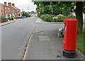
Postbox along Station Road
At the corner of The Grange.
Image: © Mat Fascione
Taken: 28 Aug 2008
0.13 miles
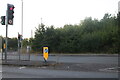
4
Junction for Earl Shilton town centre from Bypass
Image: © Pauline W
Taken: 25 Nov 2009
0.18 miles
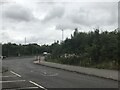
5
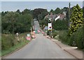
Station Road at Earl Shilton
It was closed for the construction of the Earl Shilton Bypass.
Image: © Mat Fascione
Taken: 28 Aug 2008
0.20 miles
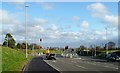
6
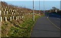
Path along the A47 Clickers Way
Part of the Earl Shilton Bypass which opened in March 2009.
Image: © Mat Fascione
Taken: 2 Jan 2015
0.23 miles