IMAGES TAKEN NEAR TO
Ambergate Close, LEICESTER, LE9 6UW
Introduction
This page details the photographs taken nearby to Ambergate Close, LE9 6UW by members of the Geograph project.
The Geograph project started in 2005 with the aim of publishing, organising and preserving representative images for every square kilometre of Great Britain, Ireland and the Isle of Man.

There are currently over 7.5m images from over14,400 individuals and you can help contribute to the project by visiting https://www.geograph.org.uk
Image Map
Images are licensed for reuse under creativecommons.org/licenses/by-sa/2.0
Notes
- Clicking on the map will re-center to the selected point.
- The higher the marker number, the further away the image location is from the centre of the postcode.
Image Listing (7 Images Found)
Images are licensed for reuse under creativecommons.org/licenses/by-sa/2.0
Image
Details
Distance
3
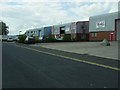
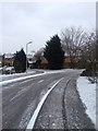
Broughton Astley-Swannington Road
Units on this small Industrial Estate.
Image: © Ian Rob
Taken: 31 May 2011
0.17 miles
4
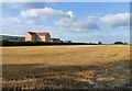
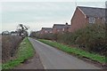
Farmland along Cottage Lane in Broughton Astley
Image: © Mat Fascione
Taken: 15 Sep 2021
0.17 miles
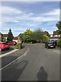
6
Cottage Lane near Broughton Astley
The houses are part of a new build on Netherfield Close in Broughton Astley.
Image: © Mat Fascione
Taken: 24 Feb 2008
0.20 miles
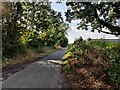
7
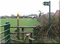
Public Footpath to Cosby
Along Cottage Lane, Broughton Astley.
Image: © Mat Fascione
Taken: 24 Feb 2008
0.20 miles