IMAGES TAKEN NEAR TO
Millers Grange, LEICESTER, LE9 6PS
Introduction
This page details the photographs taken nearby to Millers Grange, LE9 6PS by members of the Geograph project.
The Geograph project started in 2005 with the aim of publishing, organising and preserving representative images for every square kilometre of Great Britain, Ireland and the Isle of Man.

There are currently over 7.5m images from over14,400 individuals and you can help contribute to the project by visiting https://www.geograph.org.uk
Image Map
Images are licensed for reuse under creativecommons.org/licenses/by-sa/2.0
Notes
- Clicking on the map will re-center to the selected point.
- The higher the marker number, the further away the image location is from the centre of the postcode.
Image Listing (10 Images Found)
Images are licensed for reuse under creativecommons.org/licenses/by-sa/2.0
Image
Details
Distance
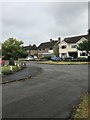
1
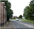
Station Road, Broughton Astley
Viewed from its junction with Broughton Way.
Image: © Mat Fascione
Taken: 28 Jul 2007
0.12 miles
2
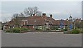
The White Horse, Broughton Astley
Large public house and restaurant on Station Road.
Image: © Mat Fascione
Taken: 24 Feb 2008
0.19 miles
3
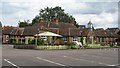
Broughton Astley White Horse
Family dining pub on Station Road
Image: © the bitterman
Taken: 3 Aug 2010
0.19 miles
6
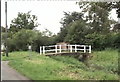
Footbridge to St Mary's Church.
This bridge allows access to the south side of the church. It crosses a brook between the church and Church Close.
Image: © Steve Rowe
Taken: 27 Jul 2007
0.22 miles
8
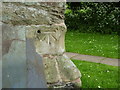
Benchmark on St Mary's church tower
This bench mark was established in 1856 during the First primary levelling of England & Wales, and was levelled with a height of 268.1220 feet [81.7236 metres] above mean sea level (Liverpool datum). It was included on the Coventry to Lincoln levelling line. The surveyor's description was "No. 35. Bolt in North-east angle of Broughton Astley Church tower ; 2.59 ft. above surface" (Public Abstract p.327). It is actually at the north-west corner of the tower. The empty hole would originally have contained the datum bolt.
Image: © Shantavira
Taken: 30 May 2015
0.23 miles
9
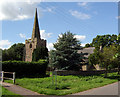
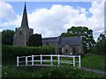
St Mary's, Broughton Astley
Access to the parish church from the old village centre of Broughton Astley is via a small footbridge over the village brook.
Image: © Kevin Flynn
Taken: 3 Jul 2007
0.23 miles
10
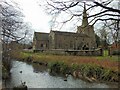
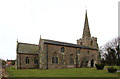
St Mary's church
The brook flows through Broughton Astley and is a tributary of the River Soar.
Image: © Tim Glover
Taken: 6 Mar 2022
0.24 miles