IMAGES TAKEN NEAR TO
LE9 5UN
Introduction
This page details the photographs taken nearby to LE9 5UN by members of the Geograph project.
The Geograph project started in 2005 with the aim of publishing, organising and preserving representative images for every square kilometre of Great Britain, Ireland and the Isle of Man.

There are currently over 7.5m images from over14,400 individuals and you can help contribute to the project by visiting https://www.geograph.org.uk
Image Map
Images are licensed for reuse under creativecommons.org/licenses/by-sa/2.0
Notes
- Clicking on the map will re-center to the selected point.
- The higher the marker number, the further away the image location is from the centre of the postcode.
Image Listing (20 Images Found)
Images are licensed for reuse under creativecommons.org/licenses/by-sa/2.0
Image
Details
Distance
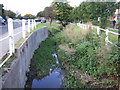
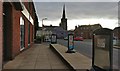
5
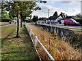
Along Cosby Brook in Cosby
The brook is next to Main Street.
Image: © Mat Fascione
Taken: 15 Sep 2021
0.19 miles
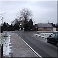
6
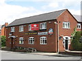
Cosby Huntsman
Modern pub on the Main Street.
Image: © the bitterman
Taken: 2 Aug 2009
0.20 miles
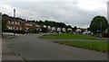
8
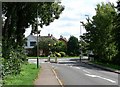
Junction in Cosby, Leicestershire
Looking south along Narborough Road towards its junction with Cambridge Road.
Image: © Mat Fascione
Taken: 28 Jul 2007
0.21 miles
9
Outside the co-operative store
Along the Main Street of Cosby. The store was formerly the Huntsman public house.
Image: © Mat Fascione
Taken: 30 Nov 2017
0.21 miles
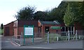
10
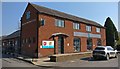
Co-op on Cosby Main Street
Formerly the Huntsman public house.
Image
Image: © Mat Fascione
Taken: 27 Mar 2020
0.21 miles