IMAGES TAKEN NEAR TO
Underwood Drive, LEICESTER, LE9 4TA
Introduction
This page details the photographs taken nearby to Underwood Drive, LE9 4TA by members of the Geograph project.
The Geograph project started in 2005 with the aim of publishing, organising and preserving representative images for every square kilometre of Great Britain, Ireland and the Isle of Man.

There are currently over 7.5m images from over14,400 individuals and you can help contribute to the project by visiting https://www.geograph.org.uk
Image Map
Images are licensed for reuse under creativecommons.org/licenses/by-sa/2.0
Notes
- Clicking on the map will re-center to the selected point.
- The higher the marker number, the further away the image location is from the centre of the postcode.
Image Listing (7 Images Found)
Images are licensed for reuse under creativecommons.org/licenses/by-sa/2.0
Image
Details
Distance
2
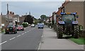
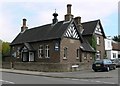
Hinckley Road, Stoney Stanton
This house was occupied between about 1890 and 1930 by the manager of the local Mountsorrel granite quarry, and he provided the land to build the chapel next door.
Image: © Eirian Evans
Taken: 14 Jan 2005
0.12 miles
3
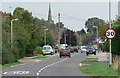
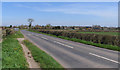
Hinckley Road in Stoney Stanton
Looking towards the spire of St Michael's Church.
Image: © Mat Fascione
Taken: 28 Aug 2008
0.13 miles
4

Methodist church, Stoney Stanton
The Methodist Church at Stoney Stanton, built on land given by my great great grandfather, adjoining his house.
Image: © Eirian Evans
Taken: 11 Sep 2006
0.16 miles
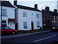
6
Stoney Stanton Social Club
On the corner of Hinckley Road and Carey Hill Road.
Image: © Mat Fascione
Taken: 28 Aug 2008
0.23 miles