IMAGES TAKEN NEAR TO
Station Road, LEICESTER, LE9 4LX
Introduction
This page details the photographs taken nearby to Station Road, LE9 4LX by members of the Geograph project.
The Geograph project started in 2005 with the aim of publishing, organising and preserving representative images for every square kilometre of Great Britain, Ireland and the Isle of Man.

There are currently over 7.5m images from over14,400 individuals and you can help contribute to the project by visiting https://www.geograph.org.uk
Image Map
Images are licensed for reuse under creativecommons.org/licenses/by-sa/2.0
Notes
- Clicking on the map will re-center to the selected point.
- The higher the marker number, the further away the image location is from the centre of the postcode.
Image Listing (3 Images Found)
Images are licensed for reuse under creativecommons.org/licenses/by-sa/2.0
Image
Details
Distance
2
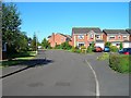
Smithy Farm Drive, Stoney Stanton
Looking WSW along Smithy Farm Drive to the junction with Taylors Close.
Image: © David P Howard
Taken: 23 Jul 2012
0.19 miles
3
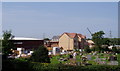
New housing at Stoney Stanton
An estate of new houses being built next to the cemetery at Stoney Stanton.
Image: © Eirian Evans
Taken: 11 Sep 2006
0.24 miles