IMAGES TAKEN NEAR TO
Sharnford Road, LEICESTER, LE9 4JN
Introduction
This page details the photographs taken nearby to Sharnford Road, LE9 4JN by members of the Geograph project.
The Geograph project started in 2005 with the aim of publishing, organising and preserving representative images for every square kilometre of Great Britain, Ireland and the Isle of Man.

There are currently over 7.5m images from over14,400 individuals and you can help contribute to the project by visiting https://www.geograph.org.uk
Image Map
Images are licensed for reuse under creativecommons.org/licenses/by-sa/2.0
Notes
- Clicking on the map will re-center to the selected point.
- The higher the marker number, the further away the image location is from the centre of the postcode.
Image Listing (29 Images Found)
Images are licensed for reuse under creativecommons.org/licenses/by-sa/2.0
Image
Details
Distance
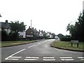
1
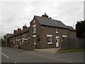
Sapcote-Calver Hill Cottages
Dating from 1882, in Sharnford Road.
Image: © Ian Rob
Taken: 9 Nov 2012
0.02 miles
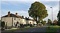
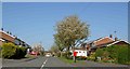
3
Houses in Sapcote
Local Authority housing stock in Sapcote.
Image: © Peter Mackenzie
Taken: 1 May 2018
0.04 miles
6
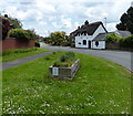
Moss Cottage on Sharnford Road, Sapcote
Image: © Mat Fascione
Taken: 3 Jun 2014
0.11 miles

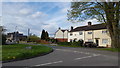
8
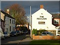
Church Street, Sapcote
Looking from the church towards the village centre.
Image: © Stephen McKay
Taken: 26 Nov 2006
0.14 miles
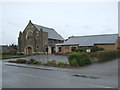
9
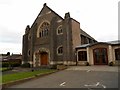
Sapcote Methodist Church
Dating from 1905 and built from local granite, the more modern church hall is attached.
Image: © Ian Rob
Taken: 9 Nov 2012
0.14 miles