IMAGES TAKEN NEAR TO
Lound Road, LEICESTER, LE9 4FH
Introduction
This page details the photographs taken nearby to Lound Road, LE9 4FH by members of the Geograph project.
The Geograph project started in 2005 with the aim of publishing, organising and preserving representative images for every square kilometre of Great Britain, Ireland and the Isle of Man.

There are currently over 7.5m images from over14,400 individuals and you can help contribute to the project by visiting https://www.geograph.org.uk
Image Map
Images are licensed for reuse under creativecommons.org/licenses/by-sa/2.0
Notes
- Clicking on the map will re-center to the selected point.
- The higher the marker number, the further away the image location is from the centre of the postcode.
Image Listing (12 Images Found)
Images are licensed for reuse under creativecommons.org/licenses/by-sa/2.0
Image
Details
Distance
3
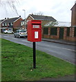
Elizabeth II postbox on Hinckley Road, Sapcote
Image: © JThomas
Taken: 25 Feb 2017
0.16 miles
4
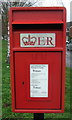
Close up, Elizabeth II postbox on Hinckley Road, Sapcote
Postbox No. LE9 175.
See Image] for wider view.
Image: © JThomas
Taken: 25 Feb 2017
0.16 miles
5
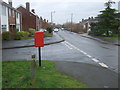
Hinckley Road, Sapcote
Showing position of Postbox No. LE9 175.
See Image] for postbox.
Image: © JThomas
Taken: 25 Feb 2017
0.16 miles
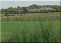
8
Park in Sapcote
A welcome open space and playing field in Sapcote.
Image: © Peter Mackenzie
Taken: 1 May 2018
0.20 miles
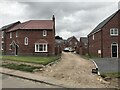
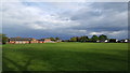
9
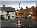
Sapcote
Looking along the B4669 towards Hinckley in the centre of the village.
Image: © Stephen McKay
Taken: 26 Nov 2006
0.24 miles
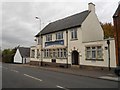
10
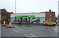
Co-operative food store, Sapcote
On Church Street.
Image: © JThomas
Taken: 25 Feb 2017
0.24 miles