IMAGES TAKEN NEAR TO
Huncote Road, LEICESTER, LE9 4DJ
Introduction
This page details the photographs taken nearby to Huncote Road, LE9 4DJ by members of the Geograph project.
The Geograph project started in 2005 with the aim of publishing, organising and preserving representative images for every square kilometre of Great Britain, Ireland and the Isle of Man.

There are currently over 7.5m images from over14,400 individuals and you can help contribute to the project by visiting https://www.geograph.org.uk
Image Map
Images are licensed for reuse under creativecommons.org/licenses/by-sa/2.0
Notes
- Clicking on the map will re-center to the selected point.
- The higher the marker number, the further away the image location is from the centre of the postcode.
Image Listing (22 Images Found)
Images are licensed for reuse under creativecommons.org/licenses/by-sa/2.0
Image
Details
Distance
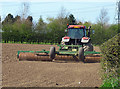
1
Footpath north of Stoney Stanton
This footpath leads off Mays Farm Drive at the northern edge of Stoney Stanton's built-up area.
Image: © Stephen McKay
Taken: 26 Nov 2006
0.09 miles
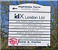
4
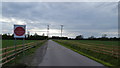
Private road to Highfields Farm
The road to Highfields Farm on the edge of Stoney Stanton.
Image: © Peter Mackenzie
Taken: 1 May 2018
0.12 miles
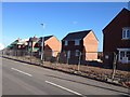
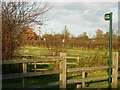
6
Bus stop and shelter on Huncote Road, Stoney Stanton
Looking north - new housing being built to the right.
Image: © JThomas
Taken: 25 Feb 2017
0.13 miles
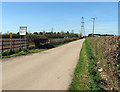
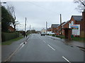
8
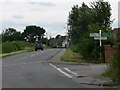
Huncote Road, Stoney Stanton
Looking south towards Stoney Stanton.
Image: © Mat Fascione
Taken: 28 Jul 2007
0.15 miles