IMAGES TAKEN NEAR TO
Elisha Close, LEICESTER, LE9 4DD
Introduction
This page details the photographs taken nearby to Elisha Close, LE9 4DD by members of the Geograph project.
The Geograph project started in 2005 with the aim of publishing, organising and preserving representative images for every square kilometre of Great Britain, Ireland and the Isle of Man.

There are currently over 7.5m images from over14,400 individuals and you can help contribute to the project by visiting https://www.geograph.org.uk
Image Map
Images are licensed for reuse under creativecommons.org/licenses/by-sa/2.0
Notes
- Clicking on the map will re-center to the selected point.
- The higher the marker number, the further away the image location is from the centre of the postcode.
Image Listing (53 Images Found)
Images are licensed for reuse under creativecommons.org/licenses/by-sa/2.0
Image
Details
Distance
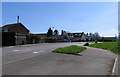
2
Stoney Stanton-Long Street
Cottages in Long Street.
Image: © Ian Rob
Taken: 9 Nov 2012
0.05 miles
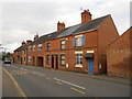
3
Long Street/Clint Hill Drive junction
The square boundary cuts across Clint Hill Drive from the street name sign and over the road and through the 7th house on the right!
Image: © Andrew Tatlow
Taken: 14 Apr 2015
0.07 miles
6
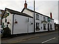
Stoney Stanton-The Blue Bell
One of three public houses in the village
Image: © Ian Rob
Taken: 9 Nov 2012
0.08 miles
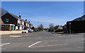
7
Looking across Long Street to the Blue Bell
Image: © Tim Glover
Taken: 13 Jun 2017
0.09 miles
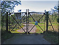
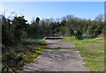
8
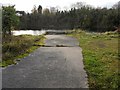
Stoney Stanton-Disused Quarry
Flooded pit to the north of the village.
Image: © Ian Rob
Taken: 9 Nov 2012
0.09 miles
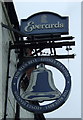
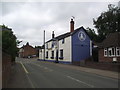
10
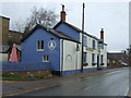
The Blue Bell, Stoney Stanton
On Long Street.
Image: © JThomas
Taken: 25 Feb 2017
0.09 miles