IMAGES TAKEN NEAR TO
Broughton Road, LEICESTER, LE9 3EE
Introduction
This page details the photographs taken nearby to Broughton Road, LE9 3EE by members of the Geograph project.
The Geograph project started in 2005 with the aim of publishing, organising and preserving representative images for every square kilometre of Great Britain, Ireland and the Isle of Man.

There are currently over 7.5m images from over14,400 individuals and you can help contribute to the project by visiting https://www.geograph.org.uk
Image Map
Images are licensed for reuse under creativecommons.org/licenses/by-sa/2.0
Notes
- Clicking on the map will re-center to the selected point.
- The higher the marker number, the further away the image location is from the centre of the postcode.
Image Listing (4 Images Found)
Images are licensed for reuse under creativecommons.org/licenses/by-sa/2.0
Image
Details
Distance
1
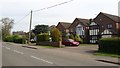
Houses in Croft
Fine example of detached houses in the village of Croft.
Image: © Peter Mackenzie
Taken: 30 Apr 2017
0.11 miles
2
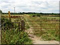
Bridleway to Sapcote
This bridleway heads from Croft across the River Soar towards Sapcote.
Image: © Stephen McKay
Taken: 6 Aug 2006
0.12 miles
3
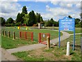
Croft Fun Park
This extensive facility for children is provided by Croft Parish Council. It is refreshingly free of graffiti and vandalism.
Image: © Stephen McKay
Taken: 6 Aug 2006
0.19 miles
4
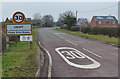
Broughton Road in Croft
This is the southern edge of the village.
Image: © Mat Fascione
Taken: 15 Feb 2015
0.24 miles