IMAGES TAKEN NEAR TO
Peers Way, LEICESTER, LE9 3BT
Introduction
This page details the photographs taken nearby to Peers Way, LE9 3BT by members of the Geograph project.
The Geograph project started in 2005 with the aim of publishing, organising and preserving representative images for every square kilometre of Great Britain, Ireland and the Isle of Man.

There are currently over 7.5m images from over14,400 individuals and you can help contribute to the project by visiting https://www.geograph.org.uk
Image Map
Images are licensed for reuse under creativecommons.org/licenses/by-sa/2.0
Notes
- Clicking on the map will re-center to the selected point.
- The higher the marker number, the further away the image location is from the centre of the postcode.
Image Listing (21 Images Found)
Images are licensed for reuse under creativecommons.org/licenses/by-sa/2.0
Image
Details
Distance
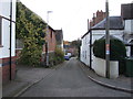
1
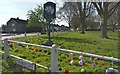
Denman Lane in Huncote
During the Coronavirus (COVID-19) Pandemic.
Image: © Mat Fascione
Taken: 8 Apr 2020
0.07 miles
2
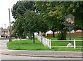
Huncote, Leicestershire
At the corner of Narborough Road and Denham Lane.
Image: © Mat Fascione
Taken: 28 Jul 2007
0.07 miles
3
Welcome to Huncote
Looking west along Huncote Road.
Image: © Mat Fascione
Taken: 28 Jul 2007
0.10 miles
4
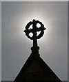
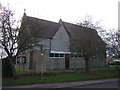
St James the Greater, Huncote
A close up of the roof of St James the Greater in Huncote, Leicestershire.
Image: © Mat Fascione
Taken: 28 Jul 2007
0.13 miles
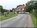
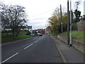
6
Narborough Road in Huncote
On the right is St James the Greater church.
Image: © Mat Fascione
Taken: 22 Dec 2013
0.14 miles
8
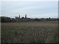
Stubble field off Huncote Road
Looking towards Huncote.
Image: © JThomas
Taken: 19 Nov 2016
0.18 miles
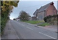
10
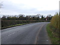
Bend in Huncote Road
Looking west near Elms Farm.
Image: © JThomas
Taken: 19 Nov 2016
0.19 miles