IMAGES TAKEN NEAR TO
Hewitt Drive, LEICESTER, LE9 2EB
Introduction
This page details the photographs taken nearby to Hewitt Drive, LE9 2EB by members of the Geograph project.
The Geograph project started in 2005 with the aim of publishing, organising and preserving representative images for every square kilometre of Great Britain, Ireland and the Isle of Man.

There are currently over 7.5m images from over14,400 individuals and you can help contribute to the project by visiting https://www.geograph.org.uk
Image Map
Images are licensed for reuse under creativecommons.org/licenses/by-sa/2.0
Notes
- Clicking on the map will re-center to the selected point.
- The higher the marker number, the further away the image location is from the centre of the postcode.
Image Listing (9 Images Found)
Images are licensed for reuse under creativecommons.org/licenses/by-sa/2.0
Image
Details
Distance
1
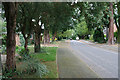
Station Road, Kirby Muxloe
Kirby Muxloe Station was opened in 1859 and closed in 1964 https://en.wikipedia.org/wiki/Kirby_Muxloe_railway_station
Image: © David Howard
Taken: 2 Jul 2023
0.08 miles
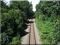
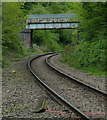
3
Bridge carries Forest Drive over the Leicester to Burton line
Image: © Tim Glover
Taken: 28 Jun 2015
0.17 miles
4
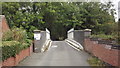
Narrow railway bridge in Forest Drive, Kirby Fields
Image: © John Welford
Taken: 1 Oct 2015
0.17 miles
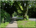
5
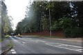
Towers Drive, Kirby Fields near Leicester
Image: © Kate Jewell
Taken: 10 Aug 2006
0.17 miles
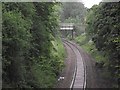
6
Forest Drive bridge crossing the Ivanhoe Line
In Kirby Fields, Leicester.
Image: © Mat Fascione
Taken: 29 Apr 2017
0.18 miles
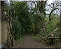
9
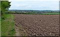
Farmland on the edge of Kirby Fields, Leicester
On the left is a footpath leading to Oakcroft Avenue in Kirby Muxloe.
Image: © Mat Fascione
Taken: 29 Apr 2017
0.25 miles