IMAGES TAKEN NEAR TO
Church Road, LEICESTER, LE9 2AD
Introduction
This page details the photographs taken nearby to Church Road, LE9 2AD by members of the Geograph project.
The Geograph project started in 2005 with the aim of publishing, organising and preserving representative images for every square kilometre of Great Britain, Ireland and the Isle of Man.

There are currently over 7.5m images from over14,400 individuals and you can help contribute to the project by visiting https://www.geograph.org.uk
Image Map
Images are licensed for reuse under creativecommons.org/licenses/by-sa/2.0
Notes
- Clicking on the map will re-center to the selected point.
- The higher the marker number, the further away the image location is from the centre of the postcode.
Image Listing (26 Images Found)
Images are licensed for reuse under creativecommons.org/licenses/by-sa/2.0
Image
Details
Distance
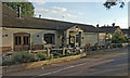
1
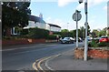
Kirby Muxloe Free Church
The Free Church in Kirby Muxloe at the corner of Church Road and Main Street. It is a clear landmark within the village.
Image: © Mike Shenton
Taken: Unknown
0.04 miles
3
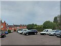
Car park, Castle Street, Kirby Muxloe
According to the entrance sign: 'Free Unlimited Parking'
Image: © Tim Heaton
Taken: 31 Aug 2023
0.06 miles
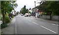
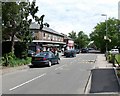
4
The Main Street of Kirby Muxloe
At the junction with Castle Road.
Image: © Mat Fascione
Taken: 9 Jun 2017
0.07 miles
9
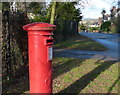
Postbox on Hedgerow Lane in Kirby Muxloe
Image: © Mat Fascione
Taken: 19 Jan 2014
0.14 miles