IMAGES TAKEN NEAR TO
Kingsfield Road, LEICESTER, LE9 1SW
Introduction
This page details the photographs taken nearby to Kingsfield Road, LE9 1SW by members of the Geograph project.
The Geograph project started in 2005 with the aim of publishing, organising and preserving representative images for every square kilometre of Great Britain, Ireland and the Isle of Man.

There are currently over 7.5m images from over14,400 individuals and you can help contribute to the project by visiting https://www.geograph.org.uk
Image Map
Images are licensed for reuse under creativecommons.org/licenses/by-sa/2.0
Notes
- Clicking on the map will re-center to the selected point.
- The higher the marker number, the further away the image location is from the centre of the postcode.
Image Listing (16 Images Found)
Images are licensed for reuse under creativecommons.org/licenses/by-sa/2.0
Image
Details
Distance
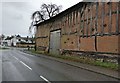
3
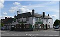
Cosby-Croft Road
Commercial premises on the corner of Park Road.
Image: © Ian Rob
Taken: 28 May 2011
0.14 miles
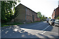
4
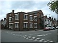
The Old Barn in Cosby
Dated 1766, this barn is on Croft Road in Cosby.
Image: © Mat Fascione
Taken: 12 Jan 2017
0.17 miles
6
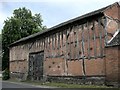
Cosby-The Old Barn
On Croft Road dates from 1766.
Image: © Ian Rob
Taken: 28 May 2011
0.18 miles
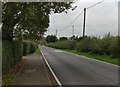
8
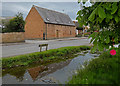
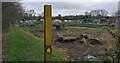
The Barn and Cosby Brook
Along Broughton Road in Cosby.
Image: © Mat Fascione
Taken: 1 May 2020
0.20 miles
9
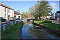
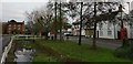
The Nook, Cosby, Leicestershire
Cosby Brook meanders through the village. It makes a focal point at The Nook and is crossed by a footbridge.
Image: © Kate Jewell
Taken: 5 May 2006
0.20 miles