IMAGES TAKEN NEAR TO
Brooklands Road, LEICESTER, LE9 1SD
Introduction
This page details the photographs taken nearby to Brooklands Road, LE9 1SD by members of the Geograph project.
The Geograph project started in 2005 with the aim of publishing, organising and preserving representative images for every square kilometre of Great Britain, Ireland and the Isle of Man.

There are currently over 7.5m images from over14,400 individuals and you can help contribute to the project by visiting https://www.geograph.org.uk
Image Map
Images are licensed for reuse under creativecommons.org/licenses/by-sa/2.0
Notes
- Clicking on the map will re-center to the selected point.
- The higher the marker number, the further away the image location is from the centre of the postcode.
Image Listing (13 Images Found)
Images are licensed for reuse under creativecommons.org/licenses/by-sa/2.0
Image
Details
Distance
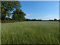
1
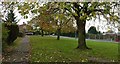
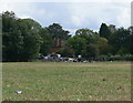
Greenspace on Brooklands Road in Cosby
Same view taken in the Spring Image
Image: © Mat Fascione
Taken: 2 Nov 2017
0.04 miles
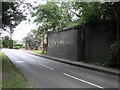
2
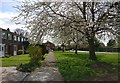
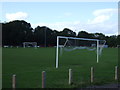
Houses on Brooklands Road in Cosby
Image same view taken in the Autumn.
Image: © Mat Fascione
Taken: 5 Apr 2017
0.06 miles
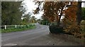
4
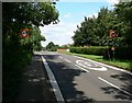
Approaching Cosby
Entering Cosby village from the north along Narborough Road.
Image: © Mat Fascione
Taken: 28 Jul 2007
0.17 miles
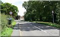
7
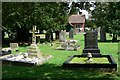
The Cemetery Chapel, Cosby
Built in 1900, this Chapel is in the cemetery on Narborough Road.
Image: © Mat Fascione
Taken: 28 Jul 2007
0.18 miles
10
Cosby-Cambridge Road
The dismantled Great Central Railway bridge.
Image: © Ian Rob
Taken: 28 May 2011
0.22 miles