IMAGES TAKEN NEAR TO
White Barn Drive, LEICESTER, LE9 1RR
Introduction
This page details the photographs taken nearby to White Barn Drive, LE9 1RR by members of the Geograph project.
The Geograph project started in 2005 with the aim of publishing, organising and preserving representative images for every square kilometre of Great Britain, Ireland and the Isle of Man.

There are currently over 7.5m images from over14,400 individuals and you can help contribute to the project by visiting https://www.geograph.org.uk
Image Map
Images are licensed for reuse under creativecommons.org/licenses/by-sa/2.0
Notes
- Clicking on the map will re-center to the selected point.
- The higher the marker number, the further away the image location is from the centre of the postcode.
Image Listing (31 Images Found)
Images are licensed for reuse under creativecommons.org/licenses/by-sa/2.0
Image
Details
Distance
1

Display at the Cosby Yarn Bomb 2021
On the corner of Park Road and the Main Street. This installation is a reference to the Cosby Victory Show, which takes place in September.
Image: © Mat Fascione
Taken: 14 Aug 2021
0.06 miles
2
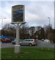
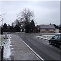
Cosby village sign
On the corner of Park Road and the Main Street.
Image: © Mat Fascione
Taken: 30 Nov 2017
0.07 miles
3
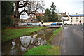
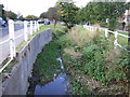
Cosby Ford
This irish bridge ford is found in the centre of Cosby.
Image: © John Walton
Taken: 18 Dec 2012
0.08 miles
4
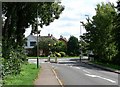
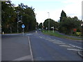
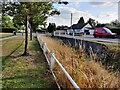
Junction in Cosby, Leicestershire
Looking south along Narborough Road towards its junction with Cambridge Road.
Image: © Mat Fascione
Taken: 28 Jul 2007
0.08 miles
6
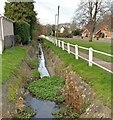
Along Cosby Brook in Cosby
The brook is next to Main Street.
Image: © Mat Fascione
Taken: 15 Sep 2021
0.09 miles