IMAGES TAKEN NEAR TO
St. Thomas's Road, LEICESTER, LE8 9EH
Introduction
This page details the photographs taken nearby to St. Thomas's Road, LE8 9EH by members of the Geograph project.
The Geograph project started in 2005 with the aim of publishing, organising and preserving representative images for every square kilometre of Great Britain, Ireland and the Isle of Man.

There are currently over 7.5m images from over14,400 individuals and you can help contribute to the project by visiting https://www.geograph.org.uk
Image Map
Images are licensed for reuse under creativecommons.org/licenses/by-sa/2.0
Notes
- Clicking on the map will re-center to the selected point.
- The higher the marker number, the further away the image location is from the centre of the postcode.
Image Listing (8 Images Found)
Images are licensed for reuse under creativecommons.org/licenses/by-sa/2.0
Image
Details
Distance
2
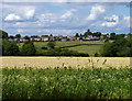
Farmland next to London Road in Great Glen
The houses are on Oaks Road.
Image: © Mat Fascione
Taken: 9 Jul 2017
0.08 miles
3
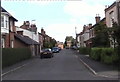
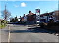
Oaks Road
The firm with the sign on is Number 33. The white houses are the oldest they were built in mid 19th Century. At that time this road was called Burton Lane.
Image: © Steve Rowe
Taken: 30 Jul 2007
0.15 miles
5
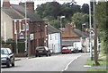
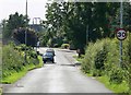
Oaks Road in Great Glen
On the right is Hillside Garage.
Image: © Mat Fascione
Taken: 2 Feb 2013
0.16 miles
7
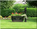
Great Glen AD 2000
Ornamental water pump and flowers at the junction of Oaks Road and Stretton Road in Great Glen, Leicestershire.
Image: © Mat Fascione
Taken: 19 Jul 2007
0.21 miles
8
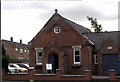
Great Glen Methodist Church Hall
It was built as a Methodist school in 19th Century. The extension to the right was built in 1989 to join it to the Church.
Image: © Steve Rowe
Taken: 14 Jul 2007
0.23 miles