IMAGES TAKEN NEAR TO
Fernie Dene, LEICESTER, LE8 9ED
Introduction
This page details the photographs taken nearby to Fernie Dene, LE8 9ED by members of the Geograph project.
The Geograph project started in 2005 with the aim of publishing, organising and preserving representative images for every square kilometre of Great Britain, Ireland and the Isle of Man.

There are currently over 7.5m images from over14,400 individuals and you can help contribute to the project by visiting https://www.geograph.org.uk
Image Map
Images are licensed for reuse under creativecommons.org/licenses/by-sa/2.0
Notes
- Clicking on the map will re-center to the selected point.
- The higher the marker number, the further away the image location is from the centre of the postcode.
Image Listing (3 Images Found)
Images are licensed for reuse under creativecommons.org/licenses/by-sa/2.0
Image
Details
Distance
1
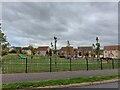
Playground at Devana Way, Great Glen
Devana Way, enclosing the playground, is a reference to the Roman road 'Via Devana', whose line is traced by modern roads and tracks a mile to the north
Image: © Tim Heaton
Taken: 4 Oct 2022
0.18 miles