IMAGES TAKEN NEAR TO
Mattock Drive, LE8 8EE
Introduction
This page details the photographs taken nearby to Mattock Drive, LE8 8EE by members of the Geograph project.
The Geograph project started in 2005 with the aim of publishing, organising and preserving representative images for every square kilometre of Great Britain, Ireland and the Isle of Man.

There are currently over 7.5m images from over14,400 individuals and you can help contribute to the project by visiting https://www.geograph.org.uk
Image Map
Images are licensed for reuse under creativecommons.org/licenses/by-sa/2.0
Notes
- Clicking on the map will re-center to the selected point.
- The higher the marker number, the further away the image location is from the centre of the postcode.
Image Listing (6 Images Found)
Images are licensed for reuse under creativecommons.org/licenses/by-sa/2.0
Image
Details
Distance
1

Leicestershire Round from Fleckney to Shearsby
Image: © Tim Glover
Taken: 30 Oct 2017
0.07 miles
2

Leicestershire Round from Fleckney to Shearsby
Image: © Tim Glover
Taken: 30 Oct 2017
0.18 miles
3
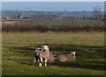
Fields and sheep north of Shearsby Road
Image: © Mat Fascione
Taken: 17 Jan 2015
0.19 miles
4

Fleckney - Badcock Way
A modern housing estate at the southern edge of Fleckney, with a peculiarly ill-chosen name for its main thoroughfare.
Image: © Peter Whatley
Taken: 7 May 2009
0.20 miles
5

Fleckney, Leicestershire
Looking northwest along Saddington Road.
Image: © Mat Fascione
Taken: 28 Apr 2007
0.23 miles
