IMAGES TAKEN NEAR TO
Leicester Road, LEICESTER, LE8 8BF
Introduction
This page details the photographs taken nearby to Leicester Road, LE8 8BF by members of the Geograph project.
The Geograph project started in 2005 with the aim of publishing, organising and preserving representative images for every square kilometre of Great Britain, Ireland and the Isle of Man.

There are currently over 7.5m images from over14,400 individuals and you can help contribute to the project by visiting https://www.geograph.org.uk
Image Map
Images are licensed for reuse under creativecommons.org/licenses/by-sa/2.0
Notes
- Clicking on the map will re-center to the selected point.
- The higher the marker number, the further away the image location is from the centre of the postcode.
Image Listing (13 Images Found)
Images are licensed for reuse under creativecommons.org/licenses/by-sa/2.0
Image
Details
Distance
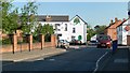
4
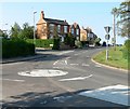
Fleckney, Leicestershire
This mini roundabout is the junction of Kilby Road, High Street, and Leicester Road.
Image: © Mat Fascione
Taken: 28 Apr 2007
0.11 miles
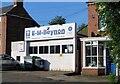
8
The High Street in Fleckney
On the left is the Old Crown public house, on the right is the Fleckney Fish Bar.
Image: © Mat Fascione
Taken: 31 Dec 2017
0.22 miles
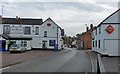
9
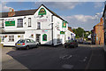
High Street, Fleckney
The heart of this large Leicestershire village with the Old Crown pub.
Image: © Stephen McKay
Taken: 8 Aug 2015
0.22 miles
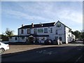
10
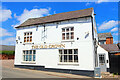
The Old Crown
Public House in Fleckney.
Image: © Wayland Smith
Taken: 12 Jun 2021
0.23 miles