IMAGES TAKEN NEAR TO
Rumsey Drive, LEICESTER, LE8 6YU
Introduction
This page details the photographs taken nearby to Rumsey Drive, LE8 6YU by members of the Geograph project.
The Geograph project started in 2005 with the aim of publishing, organising and preserving representative images for every square kilometre of Great Britain, Ireland and the Isle of Man.

There are currently over 7.5m images from over14,400 individuals and you can help contribute to the project by visiting https://www.geograph.org.uk
Image Map
Images are licensed for reuse under creativecommons.org/licenses/by-sa/2.0
Notes
- Clicking on the map will re-center to the selected point.
- The higher the marker number, the further away the image location is from the centre of the postcode.
Image Listing (20 Images Found)
Images are licensed for reuse under creativecommons.org/licenses/by-sa/2.0
Image
Details
Distance
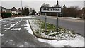
1
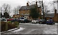
The Old Vicarage in Whetstone
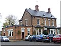
Marston's public house along the Enderby Road.
Image: © Mat Fascione
Taken: 1 Mar 2018
0.04 miles
3
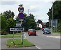
Approaching Whetstone
Looking along the B582 Enderby Road.
Image: © Mat Fascione
Taken: 28 Jul 2007
0.09 miles
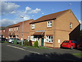
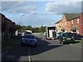
5
Enderby Road in Whetstone
During the `Beast from the East` cold spell in February/March 2018.
Image: © Mat Fascione
Taken: 1 Mar 2018
0.11 miles
7
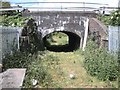
Nuneaton-Leicester Line
Under bridge off Woodyard Lane
Image: © Ian Rob
Taken: 28 May 2011
0.13 miles
8
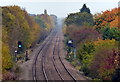
Leicester to Nuneaton Railway Line at Whetstone
Image: © Mat Fascione
Taken: 30 Oct 2016
0.14 miles
9
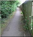
Footpath alongside the A426 Blaby Bypass
In Whetstone, Leicestershire.
Image: © Mat Fascione
Taken: 21 May 2011
0.14 miles
10
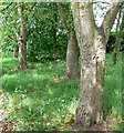
Wooded area next to the A426 Blaby Bypass
In Whetstone, Leicestershire.
Image: © Mat Fascione
Taken: 21 May 2011
0.14 miles