IMAGES TAKEN NEAR TO
Reeves Close, LEICESTER, LE8 6YQ
Introduction
This page details the photographs taken nearby to Reeves Close, LE8 6YQ by members of the Geograph project.
The Geograph project started in 2005 with the aim of publishing, organising and preserving representative images for every square kilometre of Great Britain, Ireland and the Isle of Man.

There are currently over 7.5m images from over14,400 individuals and you can help contribute to the project by visiting https://www.geograph.org.uk
Image Map
Images are licensed for reuse under creativecommons.org/licenses/by-sa/2.0
Notes
- Clicking on the map will re-center to the selected point.
- The higher the marker number, the further away the image location is from the centre of the postcode.
Image Listing (14 Images Found)
Images are licensed for reuse under creativecommons.org/licenses/by-sa/2.0
Image
Details
Distance
1
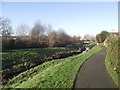
Footpath by Whetstone Brook
Leading to Badger Lane
Image: © Tim Glover
Taken: 20 Jan 2017
0.10 miles
2
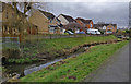
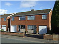
Houses next to Whetstone Brook, Whetstone
Image: © Mat Fascione
Taken: 9 Jan 2017
0.11 miles
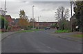
4
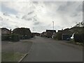
Whetstone-Dog and Gun Lane
An Arriva bus waiting for passengers.
Image: © Ian Rob
Taken: 28 May 2011
0.13 miles
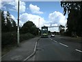
6
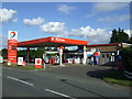
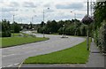
Service station on Cambridge Road, Whetstone
Image: © JThomas
Taken: 29 Sep 2012
0.19 miles
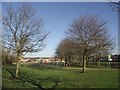
7
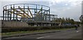
Building site next to Dog and Gun Lane in Whetstone
Image: © Mat Fascione
Taken: 7 Nov 2017
0.19 miles