IMAGES TAKEN NEAR TO
Pintail Close, LEICESTER, LE8 6XW
Introduction
This page details the photographs taken nearby to Pintail Close, LE8 6XW by members of the Geograph project.
The Geograph project started in 2005 with the aim of publishing, organising and preserving representative images for every square kilometre of Great Britain, Ireland and the Isle of Man.

There are currently over 7.5m images from over14,400 individuals and you can help contribute to the project by visiting https://www.geograph.org.uk
Image Map
Images are licensed for reuse under creativecommons.org/licenses/by-sa/2.0
Notes
- Clicking on the map will re-center to the selected point.
- The higher the marker number, the further away the image location is from the centre of the postcode.
Image Listing (14 Images Found)
Images are licensed for reuse under creativecommons.org/licenses/by-sa/2.0
Image
Details
Distance
1
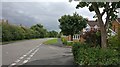
Springwell Lane in Whetstone
At the junction with Emperor Way.
Image: © Mat Fascione
Taken: 9 Aug 2017
0.10 miles
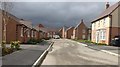
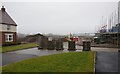
2
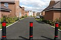
New housing estate along Springwell Lane, Whetstone
Image: © Mat Fascione
Taken: 10 Aug 2017
0.10 miles

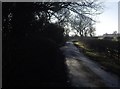
5
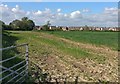
Farmland on the southern edge of Whetstone
Image: © Mat Fascione
Taken: 11 May 2020
0.19 miles
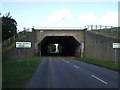
6
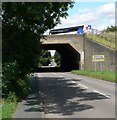
M1 Motorway bridge
Approaching Whetstone along Cambridge Road.
Image: © Mat Fascione
Taken: 28 Jul 2007
0.19 miles
8
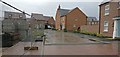
Building work on Hall Drive at Whetstone Park
A new housing estate on the southern edge of Whetstone village.
Image: © Mat Fascione
Taken: 11 Jul 2017
0.21 miles
9
Hall Lane in Whetstone
A new housing development called Whetstone Park.
Image: © Mat Fascione
Taken: 4 Apr 2018
0.21 miles
10
Construction at Whetstone Park
A new housing estate on the southern edge of Whetstone village.
Image: © Mat Fascione
Taken: 19 Jan 2017
0.22 miles