IMAGES TAKEN NEAR TO
Shenton Close, LEICESTER, LE8 6NZ
Introduction
This page details the photographs taken nearby to Shenton Close, LE8 6NZ by members of the Geograph project.
The Geograph project started in 2005 with the aim of publishing, organising and preserving representative images for every square kilometre of Great Britain, Ireland and the Isle of Man.

There are currently over 7.5m images from over14,400 individuals and you can help contribute to the project by visiting https://www.geograph.org.uk
Image Map
Images are licensed for reuse under creativecommons.org/licenses/by-sa/2.0
Notes
- Clicking on the map will re-center to the selected point.
- The higher the marker number, the further away the image location is from the centre of the postcode.
Image Listing (20 Images Found)
Images are licensed for reuse under creativecommons.org/licenses/by-sa/2.0
Image
Details
Distance
1
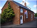
Congregational Hall
Congregational Hall, 1869, on King Street, Whetstone.
Image: © Tony Brett
Taken: 2 May 2009
0.03 miles
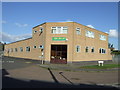
7
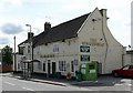
The Wheatsheaf
Public House on the High Street in Whetstone, Leicestershire.
Image: © Mat Fascione
Taken: 28 Jul 2007
0.15 miles
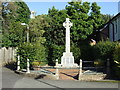
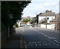
9
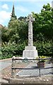
War Memorial, Whetstone
Located on the High Street, the spire of St Peter's Church is visible.
Image: © Mat Fascione
Taken: 28 Jul 2007
0.17 miles
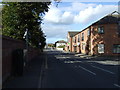
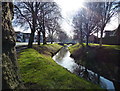
10
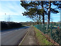
The Dicken in Whetstone
On the right of the fence is the Warwick Road Sports Ground.
Image: © Mat Fascione
Taken: 4 Feb 2017
0.17 miles