IMAGES TAKEN NEAR TO
Lutterworth Road, LEICESTER, LE8 6NA
Introduction
This page details the photographs taken nearby to Lutterworth Road, LE8 6NA by members of the Geograph project.
The Geograph project started in 2005 with the aim of publishing, organising and preserving representative images for every square kilometre of Great Britain, Ireland and the Isle of Man.

There are currently over 7.5m images from over14,400 individuals and you can help contribute to the project by visiting https://www.geograph.org.uk
Image Map
Images are licensed for reuse under creativecommons.org/licenses/by-sa/2.0
Notes
- Clicking on the map will re-center to the selected point.
- The higher the marker number, the further away the image location is from the centre of the postcode.
Image Listing (22 Images Found)
Images are licensed for reuse under creativecommons.org/licenses/by-sa/2.0
Image
Details
Distance
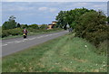
1
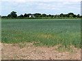
Farmland south of Whetstone
Looking towards Beeches Farm along Lutterworth Road.
Image: © Mat Fascione
Taken: 21 May 2011
0.03 miles
2
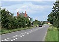
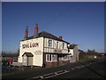
Lutterworth Road, Whetstone
The building on the left is The Dog & Gun Public House.
Image: © Mat Fascione
Taken: 28 Jul 2007
0.05 miles
3
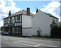
Whetstone-The Dog and Gun
Public House on Dog and Gun Lane but the front is facing the busy Lutterworth Road.
Image: © Ian Rob
Taken: 28 May 2011
0.08 miles
4
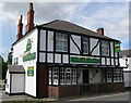
The Dog & Gun, Whetstone
Public House on Lutterworth Road in Whetstone, Leicester.
Image: © Mat Fascione
Taken: 28 Jul 2007
0.08 miles
5
The Dog & Gun and the A426, Lutterworth Road
Image: © Tim Glover
Taken: 20 Jan 2017
0.10 miles
6
Lutterworth Road towards Whetstone
The building in the distance is a Co-op superstore on Dog and Gun Lane.
Image: © Mat Fascione
Taken: 21 May 2011
0.11 miles
7
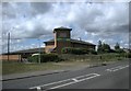
Whetstone Cooperative Store
Superstore on Dog and Gun Lane. Looking from Lutterworth Road
Image: © Ian Rob
Taken: 28 May 2011
0.11 miles
8
Flood relief basin at Whetstone
Next to Whetstone Brook in Whetstone village. The houses on the right are on Hopper Way. The white building is the Dog & Gun public house.
Image: © Mat Fascione
Taken: 19 Jan 2017
0.12 miles
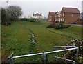
9
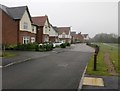
Hopper Way in Whetstone
New build housing on the southern edge of the village.
Image: © Mat Fascione
Taken: 19 Jan 2017
0.13 miles
10
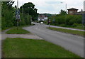
The A426 Lutterworth Road
On the southern edge of Whetstone village.
Image: © Mat Fascione
Taken: 21 May 2011
0.13 miles