IMAGES TAKEN NEAR TO
The Bank, LEICESTER, LE8 5WE
Introduction
This page details the photographs taken nearby to The Bank, LE8 5WE by members of the Geograph project.
The Geograph project started in 2005 with the aim of publishing, organising and preserving representative images for every square kilometre of Great Britain, Ireland and the Isle of Man.

There are currently over 7.5m images from over14,400 individuals and you can help contribute to the project by visiting https://www.geograph.org.uk
Image Map
Images are licensed for reuse under creativecommons.org/licenses/by-sa/2.0
Notes
- Clicking on the map will re-center to the selected point.
- The higher the marker number, the further away the image location is from the centre of the postcode.
Image Listing (28 Images Found)
Images are licensed for reuse under creativecommons.org/licenses/by-sa/2.0
Image
Details
Distance
1
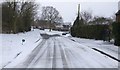
Mill Hill Road in Arnesby
During the `Beast from the East` cold spell in February/March 2018.
Image: © Mat Fascione
Taken: 1 Mar 2018
0.07 miles
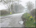
2
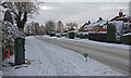
Lutterworth Road in Arnesby
During a brief snowy spell in December 2017.
Image: © Mat Fascione
Taken: 12 Dec 2017
0.07 miles
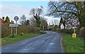
5
Hail storm on Lutterworth Road
Terrible weather on the western edge of the Leicestershire village of Arnesby.
Image: © Mat Fascione
Taken: 22 Mar 2008
0.08 miles
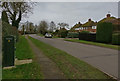
7
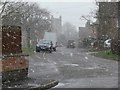
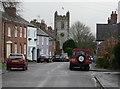
Snow storm in Arnesby
Looking south along St Peters Road towards the church.
Image: © Mat Fascione
Taken: 22 Mar 2008
0.12 miles
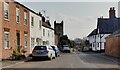
8
The Old Vicarage in Arnesby
Along St Peter's Road next to St Peter's Church.
Image: © Mat Fascione
Taken: 31 May 2022
0.12 miles
9
St. Peter's Church, Arnesby
Looking along St Peters Road.
Image: © Mat Fascione
Taken: 22 Mar 2008
0.12 miles
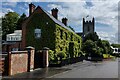
10
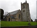
Arnesby Church
Saint Peter, dating from the 12th century.
Image: © Ian Rob
Taken: 27 Apr 2012
0.12 miles