IMAGES TAKEN NEAR TO
Larchwood, LEICESTER, LE8 5RH
Introduction
This page details the photographs taken nearby to Larchwood, LE8 5RH by members of the Geograph project.
The Geograph project started in 2005 with the aim of publishing, organising and preserving representative images for every square kilometre of Great Britain, Ireland and the Isle of Man.

There are currently over 7.5m images from over14,400 individuals and you can help contribute to the project by visiting https://www.geograph.org.uk
Image Map
Images are licensed for reuse under creativecommons.org/licenses/by-sa/2.0
Notes
- Clicking on the map will re-center to the selected point.
- The higher the marker number, the further away the image location is from the centre of the postcode.
Image Listing (22 Images Found)
Images are licensed for reuse under creativecommons.org/licenses/by-sa/2.0
Image
Details
Distance
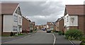
2
New housing on Jubilee Way in Countesthorpe
Image: © Mat Fascione
Taken: 10 Sep 2017
0.13 miles
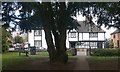
3
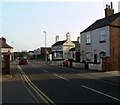
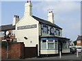
Countesthorpe near Leicester
Looking along Wigston Street, The Axe and Square public house is visible near the centre of the picture.
Image: © Mat Fascione
Taken: 14 Apr 2007
0.16 miles
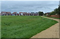
4
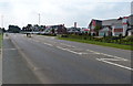
New houses at Thorpe Meadows in Countesthorpe
Along Leicester Road on the northern edge of the village.
Image: © Mat Fascione
Taken: 10 Sep 2014
0.17 miles
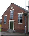
6
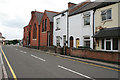
Wigston Street, Countesthorpe
Looking towards the village centre, this shows Countesthorpe Methodist Church.
Image: © Kate Jewell
Taken: 31 Aug 2006
0.21 miles
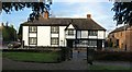
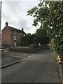
8
The Manor House in Countesthorpe
Viewed from St Andrew's churchyard.
Image: © Mat Fascione
Taken: 17 Mar 2020
0.22 miles