IMAGES TAKEN NEAR TO
Bassett Avenue, LEICESTER, LE8 5QF
Introduction
This page details the photographs taken nearby to Bassett Avenue, LE8 5QF by members of the Geograph project.
The Geograph project started in 2005 with the aim of publishing, organising and preserving representative images for every square kilometre of Great Britain, Ireland and the Isle of Man.

There are currently over 7.5m images from over14,400 individuals and you can help contribute to the project by visiting https://www.geograph.org.uk
Image Map
Images are licensed for reuse under creativecommons.org/licenses/by-sa/2.0
Notes
- Clicking on the map will re-center to the selected point.
- The higher the marker number, the further away the image location is from the centre of the postcode.
Image Listing (9 Images Found)
Images are licensed for reuse under creativecommons.org/licenses/by-sa/2.0
Image
Details
Distance
5
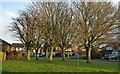
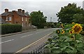
Trees along Springwell Drive in Countesthorpe
Image: © Mat Fascione
Taken: 7 Dec 2017
0.18 miles
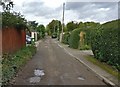
6
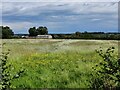
Farmland on the southern edge of Countesthorpe
Image: © Mat Fascione
Taken: 30 May 2022
0.20 miles
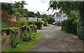
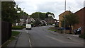
7

Westward on Station Road, Countesthorpe at Railway Inn, 1988
Until closed completely on 1/1/62, the ex-Midland Rugby (LNW) (to left) - Wigston South Junction (Leicester) (to right), a secondary main line dating from the 1840s, had run under the road just ahead. The station had been just to the right.
Image: © Ben Brooksbank
Taken: 7 Jun 1988
0.21 miles
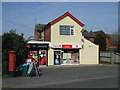
9
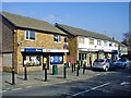
Countesthorpe-Station Road
A small parade of shops.
Image: © Ian Rob
Taken: 4 Mar 2011
0.23 miles