IMAGES TAKEN NEAR TO
Cherry Tree Close, LEICESTER, LE8 5PQ
Introduction
This page details the photographs taken nearby to Cherry Tree Close, LE8 5PQ by members of the Geograph project.
The Geograph project started in 2005 with the aim of publishing, organising and preserving representative images for every square kilometre of Great Britain, Ireland and the Isle of Man.

There are currently over 7.5m images from over14,400 individuals and you can help contribute to the project by visiting https://www.geograph.org.uk
Image Map
Images are licensed for reuse under creativecommons.org/licenses/by-sa/2.0
Notes
- Clicking on the map will re-center to the selected point.
- The higher the marker number, the further away the image location is from the centre of the postcode.
Image Listing (9 Images Found)
Images are licensed for reuse under creativecommons.org/licenses/by-sa/2.0
Image
Details
Distance
1
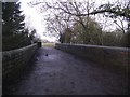
Footpath from Linden Farm Drive to Winchester Road
The bridge was built by the Midland Counties Railway to cross a cutting. Once the main line from Derby to London, the railway closed on 1 January 1962.
Image: © Tim Glover
Taken: 8 Jan 2017
0.07 miles
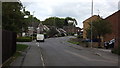
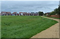
2
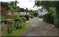
Path on the edge of Countesthorpe
The houses are on Ridleys Close.
Image: © Mat Fascione
Taken: 7 Aug 2017
0.12 miles
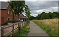
3
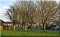
Trees along Springwell Drive in Countesthorpe
Image: © Mat Fascione
Taken: 7 Dec 2017
0.13 miles
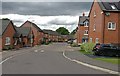
7
New housing on Jubilee Way in Countesthorpe
Image: © Mat Fascione
Taken: 10 Sep 2017
0.21 miles